Aspremont geodata
Aspremont (Provence-Alpes-Côte d'Azur) is a populated place; located in France in Europe/Paris (GMT+2) time zone. With population of 2,074 people, there are 4633 cities with bigger population in this country. Compared to other cities in France, 89.3% of cities are located further ↑North; 96.1% of cities are located further ←West and 91.9% of cities have lower elevation than Aspremont. Note1
Administrative division(s):
- Level 1: Provence-Alpes-Côte d'Azur
- Level 2: Alpes-Maritimes
- Level 3: Arrondissement de Nice
- Level 4: Aspremont


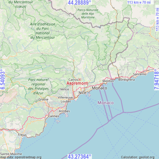
Aspremont GPS coordinates[2]
43° 47' 0.312" North, 7° 14' 38.616" East
| Map corner | latitude | longitude |
|---|---|---|
| Upper-left | 44.28889°, | 6.54093° |
| Center: | 43.78342°, | 7.24406° |
| Lower-right: | 43.27364°, | 7.94718° |
| Map W x H: | 112.9×112.9 km | = 70.2×70.2mi |
| max Lat: | 51.07786° ⇑89.3% North |
| Aspremont: | 43.78342° |
| min Lat: | ⇓10.7% South 41.3874° |
| min Long | Aspremont | max Long |
| -5.08615° | 7.24406° | 9.52242° |
| W 96.1%⇐ | ⇒3.9% E |
Elevation
Elevation of Aspremont is 472 m = 1549 ft, and this is 278.3 m = 913 ft above average elevation for this country.
| Max E: |
2333 m = 7654 ft | 8.1% |
| Aspremont | 472 m 1549 ft | |
| Avg. | 193.7 m = 635 ft | |
Min E: |
-1 m = -3 ft | 91.9% |
See also: France elevation on elevation.city.
Geographical zone
Aspremont is located in North temperate zone (between Tropic of Cancer and the Arctic Circle). Distance of this Northern Tropic circle is 2262.3 km =1405.7 mi to South.| Distance of | km | miles | from Aspremont |
|---|---|---|---|
| North Pole | 5138.8 | 3193.1 | to North |
| Arctic Circle | 2532.9 | 1573.9 | to North |
| Tropic Cancer | 2262.3 | 1405.7 | to South |
| Equator | 4868.3 | 3025 | to South |


Nearby cities:
15 places around Aspremont: (largest is in red/bold)
• Bendejun
7.1 km =4.4 mi,  34°
34°
• Cantaron
6.4 km =4 mi,  111°
111°
• Carros
4.7 km =2.9 mi,  282°
282°
• Castagniers
1.3 km =0.8 mi,  311°
311°
• Colomars
2.9 km =1.8 mi,  218°
218°
• Contes
6.5 km =4 mi,  59°
59°
• Drap
7 km =4.3 mi,  116°
116°
• Falicon
4.8 km =3 mi,  144°
144°
• Gattières
6.1 km =3.8 mi,  244°
244°
• La Roquette-sur-Var
6.1 km =3.8 mi,  324°
324°
• Le Broc
6.7 km =4.2 mi,  295°
295°
• Saint-André-de-la-Roche
6.4 km =4 mi,  150°
150°
• Saint-Blaise
4.3 km =2.7 mi,  353°
353°
• Saint-Martin-du-Var
5.8 km =3.6 mi, 312°
• Tourrette-Levens
2.6 km =1.6 mi,  82°
82°
Sources, notices
• [Note1] Compared only with cities in France existing in our database
• [Src1] Map data: © OpenStreetMap contributors (CC-BY-SA)
• [Src2] Other city data from geonames.org with taken over terms of usage.
• [Src3] Geographical zone / Annual Mean Temperature by Robert A. Rohde @ Wikipedia
