Gourdon geodata
Gourdon (Occitanie) is a seat of a third-order administrative division; located in France in Europe/Paris (GMT+2) time zone. With population of 5,342 people, there are 1844 cities with bigger population in this country. Compared to other cities in France, 81.8% of cities are located further ↑North; 64.5% of cities are located further →East and 70.4% of cities have lower elevation than Gourdon. Note1
Administrative division(s):
- Level 1: Occitanie
- Level 2: Lot
- Level 3: Arrondissement de Gourdon
- Level 4: Gourdon


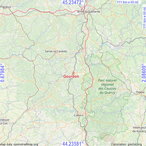
Gourdon GPS coordinates[2]
44° 44' 14.712" North, 1° 22' 58.692" East
| Map corner | latitude | longitude |
|---|---|---|
| Upper-left | 45.23472°, | 0.67984° |
| Center: | 44.73742°, | 1.38297° |
| Lower-right: | 44.23581°, | 2.08609° |
| Map W x H: | 111.1×111.1 km | = 69×69mi |
| max Lat: | 51.07786° ⇑81.8% North |
| Gourdon: | 44.73742° |
| min Lat: | ⇓18.2% South 41.3874° |
| min Long | Gourdon | max Long |
| -5.08615° | 1.38297° | 9.52242° |
| W 35.5%⇐ | ⇒64.5% E |
Elevation
Elevation of Gourdon is 221 m = 725 ft, and this is 27.3 m = 90 ft above average elevation for this country.
| Max E: |
2333 m = 7654 ft | 29.6% |
| Gourdon | 221 m 725 ft | |
| Avg. | 193.7 m = 635 ft | |
Min E: |
-1 m = -3 ft | 70.4% |
See also: France elevation on elevation.city.
Geographical zone
Gourdon is located in North temperate zone (between Tropic of Cancer and the Arctic Circle). Distance of this Northern Tropic circle is 2368.4 km =1471.7 mi to South.| Distance of | km | miles | from Gourdon |
|---|---|---|---|
| North Pole | 5032.7 | 3127.2 | to North |
| Arctic Circle | 2426.8 | 1507.9 | to North |
| Tropic Cancer | 2368.4 | 1471.7 | to South |
| Equator | 4974.3 | 3090.9 | to South |


Nearby cities:
15 places around Gourdon: (largest is in red/bold)
• Carsac-Aillac
15 km =9.3 mi,  315°
315°
• Cénac-et-Saint-Julien
15.6 km =9.7 mi,  296°
296°
• Daglan
15.1 km =9.4 mi,  272°
272°
• Domme
15.1 km =9.4 mi, 298°
• Dégagnac
9.7 km =6 mi,  213°
213°
• Groléjac
11.7 km =7.3 mi, 321°
• Le Vigan
4.5 km =2.8 mi,  85°
85°
• Montfaucon
15.2 km =9.4 mi,  111°
111°
• Payrac
9.6 km =6 mi,  46°
46°
• Payrignac
3.2 km =2 mi,  308°
308°
• Saint-Germain-du-Bel-Air
11 km =6.8 mi,  155°
155°
• Saint-Julien-de-Lampon
14.6 km =9.1 mi,  349°
349°
• Saint-Martial-de-Nabirat
9.9 km =6.2 mi, 274°
• Salviac
11.2 km =7 mi,  235°
235°
• Vitrac
15 km =9.3 mi, 315°
Sources, notices
• [Note1] Compared only with cities in France existing in our database
• [Src1] Map data: © OpenStreetMap contributors (CC-BY-SA)
• [Src2] Other city data from geonames.org with taken over terms of usage.
• [Src3] Geographical zone / Annual Mean Temperature by Robert A. Rohde @ Wikipedia
