Barbentane geodata
Barbentane (Provence-Alpes-Côte d'Azur) is a populated place; located in France in Europe/Paris (GMT+2) time zone. With population of 3,916 people, there are 2512 cities with bigger population in this country. Compared to other cities in France, 88.1% of cities are located further ↑North; 74.3% of cities are located further ←West and 68.3% of cities have higher elevation than Barbentane. Note1
Administrative division(s):
- Level 1: Provence-Alpes-Côte d'Azur
- Level 2: Département des Bouches-du-Rhône
- Level 3: Arles
- Level 4: Barbentane


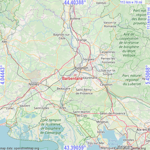
Barbentane GPS coordinates[2]
43° 53' 57.804" North, 4° 44' 51.216" East
| Map corner | latitude | longitude |
|---|---|---|
| Upper-left | 44.40388°, | 4.04443° |
| Center: | 43.89939°, | 4.74756° |
| Lower-right: | 43.39059°, | 5.45068° |
| Map W x H: | 112.7×112.7 km | = 70×70mi |
| max Lat: | 51.07786° ⇑88.1% North |
| Barbentane: | 43.89939° |
| min Lat: | ⇓11.9% South 41.3874° |
| min Long | Barbentane | max Long |
| -5.08615° | 4.74756° | 9.52242° |
| W 74.3%⇐ | ⇒25.7% E |
Elevation
Elevation of Barbentane is 82 m = 269 ft, and this is 111.7 m = 366 ft below average elevation for this country.
| Max E: |
2333 m = 7654 ft | 68.3% |
| Avg. | 193.7 m = 635 ft | |
| Barbentane | 82 m = 269 ft | |
Min E: |
-1 m = -3 ft | 31.7% |
See also: France elevation on elevation.city.
Geographical zone
Barbentane is located in North temperate zone (between Tropic of Cancer and the Arctic Circle). Distance of this Northern Tropic circle is 2275.2 km =1413.7 mi to South.| Distance of | km | miles | from Barbentane |
|---|---|---|---|
| North Pole | 5125.9 | 3185.1 | to North |
| Arctic Circle | 2520 | 1565.9 | to North |
| Tropic Cancer | 2275.2 | 1413.7 | to South |
| Equator | 4881.2 | 3033 | to South |


Nearby cities:
15 places around Barbentane: (largest is in red/bold)
• Aramon
5.4 km =3.4 mi,  260°
260°
• Avignon
7.3 km =4.5 mi,  42°
42°
• Boulbon
6 km =3.7 mi,  226°
226°
• Châteaurenard
8.8 km =5.5 mi,  102°
102°
• Domazan
8.4 km =5.2 mi,  292°
292°
• Eyragues
10 km =6.2 mi,  130°
130°
• Graveson
5.8 km =3.6 mi,  158°
158°
• Les Angles
6.6 km =4.1 mi,  11°
11°
• Maillane
7.9 km =4.9 mi, 159°
• Montfavet
10.8 km =6.7 mi,  69°
69°
• Rochefort-du-Gard
9.7 km =6 mi,  331°
331°
• Rognonas
4.5 km =2.8 mi,  89°
89°
• Saze
7.2 km =4.5 mi,  312°
312°
• Théziers
10.1 km =6.3 mi,  270°
270°
• Villeneuve-lès-Avignon
8.6 km =5.3 mi,  26°
26°
Sources, notices
• [Note1] Compared only with cities in France existing in our database
• [Src1] Map data: © OpenStreetMap contributors (CC-BY-SA)
• [Src2] Other city data from geonames.org with taken over terms of usage.
• [Src3] Geographical zone / Annual Mean Temperature by Robert A. Rohde @ Wikipedia
