Gennes-sur-Seiche geodata
Gennes-sur-Seiche (Brittany) is a populated place; located in France in Europe/Paris (GMT+2) time zone. With population of 767 people, there are 10982 cities with bigger population in this country. Compared to other cities in France, 59% of cities are located further ↓South; 89.4% of cities are located further →East and 70.1% of cities have higher elevation than Gennes-sur-Seiche. Note1
Administrative division(s):
- Level 1: Brittany
- Level 2: Département d'Ille-et-Vilaine
- Level 3: Arrondissement de Fougères-Vitré
- Level 4: Gennes-sur-Seiche


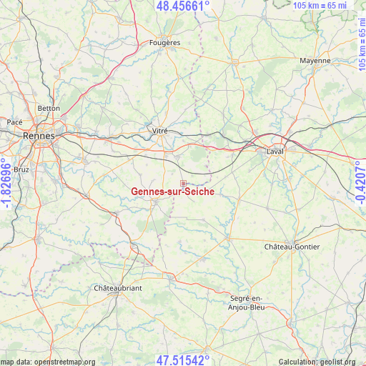
Gennes-sur-Seiche GPS coordinates[2]
47° 59' 17.376" North, 1° 7' 25.788" West
| Map corner | latitude | longitude |
|---|---|---|
| Upper-left | 48.45661°, | -1.82696° |
| Center: | 47.98816°, | -1.12383° |
| Lower-right: | 47.51542°, | -0.4207° |
| Map W x H: | 104.7×104.6 km | = 65.1×65mi |
| max Lat: | 51.07786° ⇑41% North |
| Gennes-sur-Seiche: | 47.98816° |
| min Lat: | ⇓59% South 41.3874° |
| min Long | Gennes-sur-Seic | max Long |
| -5.08615° | -1.12383° | 9.52242° |
| W 10.6%⇐ | ⇒89.4% E |
Elevation
Elevation of Gennes-sur-Seiche is 78 m = 256 ft, and this is 115.7 m = 380 ft below average elevation for this country.
| Max E: |
2333 m = 7654 ft | 70.1% |
| Avg. | 193.7 m = 635 ft | |
| Gennes-sur-Seiche | 78 m = 256 ft | |
Min E: |
-1 m = -3 ft | 29.9% |
See also: France elevation on elevation.city.
Geographical zone
Gennes-sur-Seiche is located in North temperate zone (between Tropic of Cancer and the Arctic Circle). Distance of this North polar circle is 2065.4 km =1283.4 mi to North.| Distance of | km | miles | from Gennes-sur-Seiche |
|---|---|---|---|
| North Pole | 4671.3 | 2902.6 | to North |
| Arctic Circle | 2065.4 | 1283.4 | to North |
| Tropic Cancer | 2729.9 | 1696.3 | to South |
| Equator | 5335.8 | 3315.5 | to South |


Nearby cities:
15 places around Gennes-sur-Seiche: (largest is in red/bold)
• Argentré-du-Plessis
7.8 km =4.8 mi,  347°
347°
• Availles-sur-Seiche
6.2 km =3.9 mi,  241°
241°
• Ballots
11.7 km =7.3 mi,  150°
150°
• Brielles
3.4 km =2.1 mi,  48°
48°
• Cuillé
2 km =1.2 mi,  170°
170°
• Domalain
8.9 km =5.5 mi,  275°
275°
• La Guerche-de-Bretagne
9.4 km =5.8 mi, 236°
• Le Pertre
8.2 km =5.1 mi, 51°
• Mondevert
10.7 km =6.6 mi,  9°
9°
• Moutiers
7.1 km =4.4 mi,  250°
250°
• Méral
11 km =6.8 mi,  106°
106°
• Rannée
11.3 km =7 mi,  230°
230°
• Saint-Cyr-le-Gravelais
8.9 km =5.5 mi, 54°
• Saint-Germain-du-Pinel
4.2 km =2.6 mi,  309°
309°
• Étrelles
9.6 km =6 mi,  326°
326°
Sources, notices
• [Note1] Compared only with cities in France existing in our database
• [Src1] Map data: © OpenStreetMap contributors (CC-BY-SA)
• [Src2] Other city data from geonames.org with taken over terms of usage.
• [Src3] Geographical zone / Annual Mean Temperature by Robert A. Rohde @ Wikipedia
