Diémoz geodata
Diémoz (Auvergne-Rhône-Alpes) is a populated place; located in France in Europe/Paris (GMT+2) time zone. With population of 2,418 people, there are 3998 cities with bigger population in this country. Compared to other cities in France, 72.7% of cities are located further ↑North; 78.6% of cities are located further ←West and 87.9% of cities have lower elevation than Diémoz. Note1
Administrative division(s):
- Level 1: Auvergne-Rhône-Alpes
- Level 2: Département de l'Isère
- Level 3: Arrondissement de Vienne
- Level 4: Diémoz


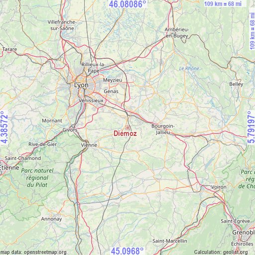
Diémoz GPS coordinates[2]
45° 35' 27.564" North, 5° 5' 19.824" East
| Map corner | latitude | longitude |
|---|---|---|
| Upper-left | 46.08086°, | 4.38572° |
| Center: | 45.59099°, | 5.08884° |
| Lower-right: | 45.0968°, | 5.79197° |
| Map W x H: | 109.4×109.4 km | = 68×68mi |
| max Lat: | 51.07786° ⇑72.7% North |
| Diémoz: | 45.59099° |
| min Lat: | ⇓27.3% South 41.3874° |
| min Long | Diémoz | max Long |
| -5.08615° | 5.08884° | 9.52242° |
| W 78.6%⇐ | ⇒21.4% E |
Elevation
Elevation of Diémoz is 388 m = 1273 ft, and this is 194.3 m = 637 ft above average elevation for this country.
| Max E: |
2333 m = 7654 ft | 12.1% |
| Diémoz | 388 m 1273 ft | |
| Avg. | 193.7 m = 635 ft | |
Min E: |
-1 m = -3 ft | 87.9% |
See also: France elevation on elevation.city.
Geographical zone
Diémoz is located in North temperate zone (between Tropic of Cancer and the Arctic Circle). Distance of this North polar circle is 2331.9 km =1449 mi to North.| Distance of | km | miles | from Diémoz |
|---|---|---|---|
| North Pole | 4937.8 | 3068.2 | to North |
| Arctic Circle | 2331.9 | 1449 | to North |
| Tropic Cancer | 2463.3 | 1530.6 | to South |
| Equator | 5069.2 | 3149.9 | to South |


Nearby cities:
15 places around Diémoz: (largest is in red/bold)
• Beauvoir-de-Marc
7.9 km =4.9 mi,  185°
185°
• Bonnefamille
3 km =1.9 mi,  71°
71°
• Charantonnay
6.2 km =3.9 mi,  164°
164°
• Four
8.2 km =5.1 mi,  93°
93°
• Grenay
8.1 km =5 mi,  355°
355°
• Heyrieux
5 km =3.1 mi,  336°
336°
• La Verpillière
6.5 km =4 mi,  42°
42°
• Oytier-Saint-Oblas
5.8 km =3.6 mi,  230°
230°
• Roche
5.7 km =3.5 mi, 94°
• Saint-Just-Chaleyssin
7 km =4.3 mi,  272°
272°
• Saint-Quentin-Fallavier
6.1 km =3.8 mi,  17°
17°
• Septème
7.7 km =4.8 mi,  236°
236°
• Valencin
5.1 km =3.2 mi,  295°
295°
• Vaulx-Milieu
7.8 km =4.8 mi, 71°
• Villefontaine
5.4 km =3.4 mi,  63°
63°
Sources, notices
• [Note1] Compared only with cities in France existing in our database
• [Src1] Map data: © OpenStreetMap contributors (CC-BY-SA)
• [Src2] Other city data from geonames.org with taken over terms of usage.
• [Src3] Geographical zone / Annual Mean Temperature by Robert A. Rohde @ Wikipedia
