Septème geodata
Septème (Auvergne-Rhône-Alpes) is a populated place; located in France in Europe/Paris (GMT+2) time zone. With population of 1,718 people, there are 5473 cities with bigger population in this country. Compared to other cities in France, 73.3% of cities are located further ↑North; 77.7% of cities are located further ←West and 75.4% of cities have lower elevation than Septème. Note1
Administrative division(s):
- Level 1: Auvergne-Rhône-Alpes
- Level 2: Département de l'Isère
- Level 3: Arrondissement de Vienne
- Level 4: Septème


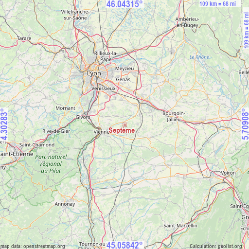
Septème GPS coordinates[2]
45° 33' 10.584" North, 5° 0' 21.456" East
| Map corner | latitude | longitude |
|---|---|---|
| Upper-left | 46.04315°, | 4.30283° |
| Center: | 45.55294°, | 5.00596° |
| Lower-right: | 45.05842°, | 5.70908° |
| Map W x H: | 109.5×109.5 km | = 68×68mi |
| max Lat: | 51.07786° ⇑73.3% North |
| Septème: | 45.55294° |
| min Lat: | ⇓26.7% South 41.3874° |
| min Long | Septème | max Long |
| -5.08615° | 5.00596° | 9.52242° |
| W 77.7%⇐ | ⇒22.3% E |
Elevation
Elevation of Septème is 252 m = 827 ft, and this is 58.3 m = 191 ft above average elevation for this country.
| Max E: |
2333 m = 7654 ft | 24.6% |
| Septème | 252 m 827 ft | |
| Avg. | 193.7 m = 635 ft | |
Min E: |
-1 m = -3 ft | 75.4% |
See also: France elevation on elevation.city.
Geographical zone
Septème is located in North temperate zone (between Tropic of Cancer and the Arctic Circle). Distance of this North polar circle is 2336.2 km =1451.6 mi to North.| Distance of | km | miles | from Septème |
|---|---|---|---|
| North Pole | 4942 | 3070.8 | to North |
| Arctic Circle | 2336.2 | 1451.6 | to North |
| Tropic Cancer | 2459.1 | 1528 | to South |
| Equator | 5065 | 3147.2 | to South |


Nearby cities:
15 places around Septème: (largest is in red/bold)
• Beauvoir-de-Marc
6.8 km =4.2 mi,  122°
122°
• Charantonnay
8.3 km =5.2 mi,  102°
102°
• Diémoz
7.7 km =4.8 mi,  56°
56°
• Estrablin
5.4 km =3.4 mi,  219°
219°
• Eyzin-Pinet
8.8 km =5.5 mi,  183°
183°
• Heyrieux
9.8 km =6.1 mi,  26°
26°
• Luzinay
5.5 km =3.4 mi,  318°
318°
• Moidieu
4 km =2.5 mi, 178°
• Oytier-Saint-Oblas
2 km =1.2 mi,  75°
75°
• Pont-Évêque
7.9 km =4.9 mi,  252°
252°
• Saint-Just-Chaleyssin
4.6 km =2.9 mi,  352°
352°
• Savas
6.7 km =4.2 mi,  141°
141°
• Serpaize
6.9 km =4.3 mi,  274°
274°
• Valencin
6.7 km =4.2 mi,  15°
15°
• Villette-de-Vienne
8.2 km =5.1 mi,  300°
300°
Sources, notices
• [Note1] Compared only with cities in France existing in our database
• [Src1] Map data: © OpenStreetMap contributors (CC-BY-SA)
• [Src2] Other city data from geonames.org with taken over terms of usage.
• [Src3] Geographical zone / Annual Mean Temperature by Robert A. Rohde @ Wikipedia
