Grenay geodata
Grenay (Auvergne-Rhône-Alpes) is a populated place; located in France in Europe/Paris (GMT+2) time zone. With population of 1,286 people, there are 7096 cities with bigger population in this country. Compared to other cities in France, 71.5% of cities are located further ↑North; 78.5% of cities are located further ←West and 81% of cities have lower elevation than Grenay. Note1
Administrative division(s):
- Level 1: Auvergne-Rhône-Alpes
- Level 2: Département de l'Isère
- Level 3: Arrondissement de Vienne
- Level 4: Grenay


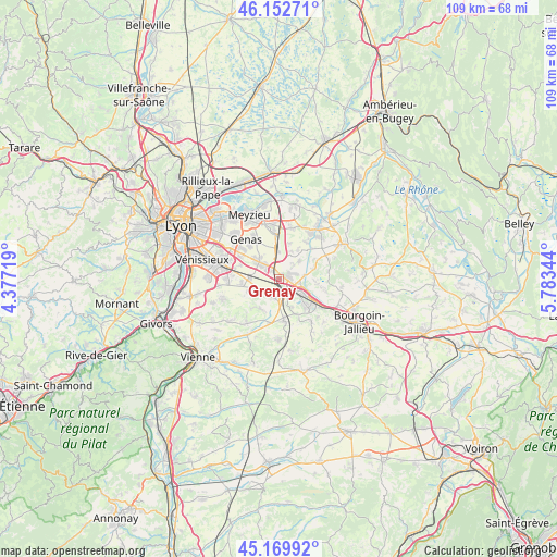
Grenay GPS coordinates[2]
45° 39' 48.492" North, 5° 4' 49.116" East
| Map corner | latitude | longitude |
|---|---|---|
| Upper-left | 46.15271°, | 4.37719° |
| Center: | 45.66347°, | 5.08031° |
| Lower-right: | 45.16992°, | 5.78344° |
| Map W x H: | 109.3×109.3 km | = 67.9×67.9mi |
| max Lat: | 51.07786° ⇑71.5% North |
| Grenay: | 45.66347° |
| min Lat: | ⇓28.5% South 41.3874° |
| min Long | Grenay | max Long |
| -5.08615° | 5.08031° | 9.52242° |
| W 78.5%⇐ | ⇒21.5% E |
Elevation
Elevation of Grenay is 300 m = 984 ft, and this is 106.3 m = 349 ft above average elevation for this country.
| Max E: |
2333 m = 7654 ft | 19% |
| Grenay | 300 m 984 ft | |
| Avg. | 193.7 m = 635 ft | |
Min E: |
-1 m = -3 ft | 81% |
See also: France elevation on elevation.city.
Geographical zone
Grenay is located in North temperate zone (between Tropic of Cancer and the Arctic Circle). Distance of this North polar circle is 2323.9 km =1444 mi to North.| Distance of | km | miles | from Grenay |
|---|---|---|---|
| North Pole | 4929.8 | 3063.2 | to North |
| Arctic Circle | 2323.9 | 1444 | to North |
| Tropic Cancer | 2471.4 | 1535.7 | to South |
| Equator | 5077.3 | 3154.9 | to South |


Nearby cities:
15 places around Grenay: (largest is in red/bold)
• Bonnefamille
7.9 km =4.9 mi,  153°
153°
• Chamagnieu
7.2 km =4.5 mi,  73°
73°
• Diémoz
8.1 km =5 mi,  175°
175°
• Frontonas
9.3 km =5.8 mi,  102°
102°
• Heyrieux
3.8 km =2.4 mi,  201°
201°
• La Verpillière
6 km =3.7 mi,  122°
122°
• Panossas
9.7 km =6 mi,  81°
81°
• Saint-Bonnet-de-Mure
5 km =3.1 mi,  306°
306°
• Saint-Laurent-de-Mure
3.7 km =2.3 mi, 311°
• Saint-Pierre-de-Chandieu
5.4 km =3.4 mi,  249°
249°
• Saint-Quentin-Fallavier
3.4 km =2.1 mi,  131°
131°
• Satolas-et-Bonce
5.1 km =3.2 mi,  49°
49°
• Toussieu
7.5 km =4.7 mi,  262°
262°
• Valencin
7 km =4.3 mi,  214°
214°
• Villefontaine
7.8 km =4.8 mi,  135°
135°
Sources, notices
• [Note1] Compared only with cities in France existing in our database
• [Src1] Map data: © OpenStreetMap contributors (CC-BY-SA)
• [Src2] Other city data from geonames.org with taken over terms of usage.
• [Src3] Geographical zone / Annual Mean Temperature by Robert A. Rohde @ Wikipedia
