Heyrieux geodata
Heyrieux (Auvergne-Rhône-Alpes) is a populated place; located in France in Europe/Paris (GMT+2) time zone. With population of 4,475 people, there are 2204 cities with bigger population in this country. Compared to other cities in France, 72.1% of cities are located further ↑North; 78.3% of cities are located further ←West and 80% of cities have lower elevation than Heyrieux. Note1
Administrative division(s):
- Level 1: Auvergne-Rhône-Alpes
- Level 2: Département de l'Isère
- Level 3: Arrondissement de Vienne
- Level 4: Heyrieux


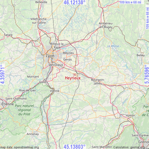
Heyrieux GPS coordinates[2]
45° 37' 54.696" North, 5° 3' 46.224" East
| Map corner | latitude | longitude |
|---|---|---|
| Upper-left | 46.12138°, | 4.35971° |
| Center: | 45.63186°, | 5.06284° |
| Lower-right: | 45.13803°, | 5.76596° |
| Map W x H: | 109.3×109.3 km | = 67.9×67.9mi |
| max Lat: | 51.07786° ⇑72.1% North |
| Heyrieux: | 45.63186° |
| min Lat: | ⇓27.9% South 41.3874° |
| min Long | Heyrieux | max Long |
| -5.08615° | 5.06284° | 9.52242° |
| W 78.3%⇐ | ⇒21.7% E |
Elevation
Elevation of Heyrieux is 290 m = 951 ft, and this is 96.3 m = 316 ft above average elevation for this country.
| Max E: |
2333 m = 7654 ft | 20% |
| Heyrieux | 290 m 951 ft | |
| Avg. | 193.7 m = 635 ft | |
Min E: |
-1 m = -3 ft | 80% |
See also: France elevation on elevation.city.
Geographical zone
Heyrieux is located in North temperate zone (between Tropic of Cancer and the Arctic Circle). Distance of this North polar circle is 2327.4 km =1446.2 mi to North.| Distance of | km | miles | from Heyrieux |
|---|---|---|---|
| North Pole | 4933.3 | 3065.4 | to North |
| Arctic Circle | 2327.4 | 1446.2 | to North |
| Tropic Cancer | 2467.9 | 1533.5 | to South |
| Equator | 5073.8 | 3152.7 | to South |


Nearby cities:
15 places around Heyrieux: (largest is in red/bold)
• Bonnefamille
6 km =3.7 mi,  126°
126°
• Diémoz
5 km =3.1 mi,  156°
156°
• Grenay
3.8 km =2.4 mi,  21°
21°
• La Verpillière
6.4 km =4 mi,  87°
87°
• Oytier-Saint-Oblas
8.6 km =5.3 mi,  196°
196°
• Roche
9.2 km =5.7 mi,  122°
122°
• Saint-Bonnet-de-Mure
7 km =4.3 mi,  338°
338°
• Saint-Just-Chaleyssin
6.5 km =4 mi,  230°
230°
• Saint-Laurent-de-Mure
6.1 km =3.8 mi,  346°
346°
• Saint-Pierre-de-Chandieu
4.1 km =2.5 mi,  293°
293°
• Saint-Quentin-Fallavier
4.1 km =2.5 mi,  71°
71°
• Satolas-et-Bonce
8.6 km =5.3 mi,  37°
37°
• Toussieu
6.6 km =4.1 mi, 292°
• Valencin
3.5 km =2.2 mi, 228°
• Villefontaine
7.1 km =4.4 mi,  107°
107°
Sources, notices
• [Note1] Compared only with cities in France existing in our database
• [Src1] Map data: © OpenStreetMap contributors (CC-BY-SA)
• [Src2] Other city data from geonames.org with taken over terms of usage.
• [Src3] Geographical zone / Annual Mean Temperature by Robert A. Rohde @ Wikipedia
