Oytier-Saint-Oblas geodata
Oytier-Saint-Oblas (Auvergne-Rhône-Alpes) is a populated place; located in France in Europe/Paris (GMT+2) time zone. With population of 1,453 people, there are 6358 cities with bigger population in this country. Compared to other cities in France, 73.3% of cities are located further ↑North; 78% of cities are located further ←West and 81% of cities have lower elevation than Oytier-Saint-Oblas. Note1
Administrative division(s):
- Level 1: Auvergne-Rhône-Alpes
- Level 2: Département de l'Isère
- Level 3: Arrondissement de Vienne
- Level 4: Oytier-Saint-Oblas


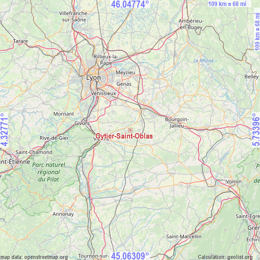
Oytier-Saint-Oblas GPS coordinates[2]
45° 33' 27.252" North, 5° 1' 50.988" East
| Map corner | latitude | longitude |
|---|---|---|
| Upper-left | 46.04774°, | 4.32771° |
| Center: | 45.55757°, | 5.03083° |
| Lower-right: | 45.06309°, | 5.73396° |
| Map W x H: | 109.5×109.5 km | = 68×68mi |
| max Lat: | 51.07786° ⇑73.3% North |
| Oytier-Saint-Oblas: | 45.55757° |
| min Lat: | ⇓26.7% South 41.3874° |
| min Long | Oytier-Saint-Ob | max Long |
| -5.08615° | 5.03083° | 9.52242° |
| W 78%⇐ | ⇒22% E |
Elevation
Elevation of Oytier-Saint-Oblas is 300 m = 984 ft, and this is 106.3 m = 349 ft above average elevation for this country.
| Max E: |
2333 m = 7654 ft | 19% |
| Oytier-Saint-Oblas | 300 m 984 ft | |
| Avg. | 193.7 m = 635 ft | |
Min E: |
-1 m = -3 ft | 81% |
See also: France elevation on elevation.city.
Geographical zone
Oytier-Saint-Oblas is located in North temperate zone (between Tropic of Cancer and the Arctic Circle). Distance of this North polar circle is 2335.6 km =1451.3 mi to North.| Distance of | km | miles | from Oytier-Saint-Oblas |
|---|---|---|---|
| North Pole | 4941.5 | 3070.5 | to North |
| Arctic Circle | 2335.6 | 1451.3 | to North |
| Tropic Cancer | 2459.6 | 1528.3 | to South |
| Equator | 5065.5 | 3147.6 | to South |


Nearby cities:
15 places around Oytier-Saint-Oblas: (largest is in red/bold)
• Beauvoir-de-Marc
5.6 km =3.5 mi,  137°
137°
• Bonnefamille
8.7 km =5.4 mi,  57°
57°
• Charantonnay
6.6 km =4.1 mi,  110°
110°
• Diémoz
5.8 km =3.6 mi,  50°
50°
• Estrablin
7.1 km =4.4 mi,  228°
228°
• Eyzin-Pinet
9.7 km =6 mi,  195°
195°
• Heyrieux
8.6 km =5.3 mi,  16°
16°
• Luzinay
6.7 km =4.2 mi,  302°
302°
• Moidieu
4.9 km =3 mi, 201°
• Saint-Just-Chaleyssin
4.8 km =3 mi,  328°
328°
• Savas
6.2 km =3.9 mi,  158°
158°
• Septème
2 km =1.2 mi,  255°
255°
• Serpaize
8.8 km =5.5 mi,  270°
270°
• Valencin
6 km =3.7 mi,  358°
358°
• Villette-de-Vienne
9.7 km =6 mi,  292°
292°
Sources, notices
• [Note1] Compared only with cities in France existing in our database
• [Src1] Map data: © OpenStreetMap contributors (CC-BY-SA)
• [Src2] Other city data from geonames.org with taken over terms of usage.
• [Src3] Geographical zone / Annual Mean Temperature by Robert A. Rohde @ Wikipedia
