Saint-Brice-sous-Forêt geodata
Saint-Brice-sous-Forêt (Île-de-France) is a populated place; located in France in Europe/Paris (GMT+2) time zone. With population of 13,606 people, there are 699 cities with bigger population in this country. Compared to other cities in France, 79.7% of cities are located further ↓South; 51.8% of cities are located further →East and 67.4% of cities have higher elevation than Saint-Brice-sous-Forêt. Note1
Administrative division(s):
- Level 1: Île-de-France
- Level 2: Département du Val-d’Oise
- Level 3: Arrondissement de Sarcelles
- Level 4: Saint-Brice-sous-Forêt


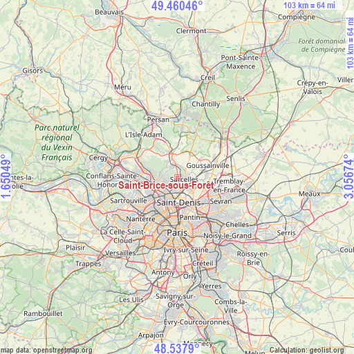
Saint-Brice-sous-Forêt GPS coordinates[2]
49° 0' 4.752" North, 2° 21' 12.996" East
| Map corner | latitude | longitude |
|---|---|---|
| Upper-left | 49.46046°, | 1.65049° |
| Center: | 49.00132°, | 2.35361° |
| Lower-right: | 48.5379°, | 3.05674° |
| Map W x H: | 102.6×102.6 km | = 63.8×63.8mi |
| max Lat: | 51.07786° ⇑20.3% North |
| Saint-Brice-sous-Forêt: | 49.00132° |
| min Lat: | ⇓79.7% South 41.3874° |
| min Long | Saint-Brice-sou | max Long |
| -5.08615° | 2.35361° | 9.52242° |
| W 48.2%⇐ | ⇒51.8% E |
Elevation
Elevation of Saint-Brice-sous-Forêt is 84 m = 276 ft, and this is 109.7 m = 360 ft below average elevation for this country.
| Max E: |
2333 m = 7654 ft | 67.4% |
| Avg. | 193.7 m = 635 ft | |
| Saint-Brice-sous-Forêt | 84 m = 276 ft | |
Min E: |
-1 m = -3 ft | 32.6% |
See also: France elevation on elevation.city.
Geographical zone
Saint-Brice-sous-Forêt is located in North temperate zone (between Tropic of Cancer and the Arctic Circle). Distance of this North polar circle is 1952.7 km =1213.4 mi to North.| Distance of | km | miles | from Saint-Brice-sous-Forêt |
|---|---|---|---|
| North Pole | 4558.6 | 2832.6 | to North |
| Arctic Circle | 1952.7 | 1213.4 | to North |
| Tropic Cancer | 2842.5 | 1766.2 | to South |
| Equator | 5448.4 | 3385.5 | to South |


Nearby cities:
15 places around Saint-Brice-sous-Forêt: (largest is in red/bold)
• Andilly
3.8 km =2.4 mi,  283°
283°
• Deuil-la-Barre
3.3 km =2.1 mi,  215°
215°
• Domont
3.6 km =2.2 mi,  326°
326°
• Enghien-les-Bains
4.7 km =2.9 mi,  214°
214°
• Groslay
1.8 km =1.1 mi,  194°
194°
• Margency
3.9 km =2.4 mi,  267°
267°
• Montmagny
3.1 km =1.9 mi, 188°
• Montmorency
1.6 km =1 mi, 207°
• Pierrefitte-sur-Seine
3.9 km =2.4 mi,  171°
171°
• Piscop
1.4 km =0.9 mi, 333°
• Sarcelles
1.8 km =1.1 mi,  103°
103°
• Soisy-sous-Montmorency
4.1 km =2.5 mi,  248°
248°
• Villiers-le-Bel
3.4 km =2.1 mi,  75°
75°
• Écouen
3 km =1.9 mi,  45°
45°
• Ézanville
3.1 km =1.9 mi,  19°
19°
Sources, notices
• [Note1] Compared only with cities in France existing in our database
• [Src1] Map data: © OpenStreetMap contributors (CC-BY-SA)
• [Src2] Other city data from geonames.org with taken over terms of usage.
• [Src3] Geographical zone / Annual Mean Temperature by Robert A. Rohde @ Wikipedia
