Delettes geodata
Delettes (Hauts-de-France) is a populated place; located in France in Europe/Paris (GMT+2) time zone. With population of 935 people, there are 9342 cities with bigger population in this country. Compared to other cities in France, 98.2% of cities are located further ↓South; 54.2% of cities are located further →East and 84.5% of cities have higher elevation than Delettes. Note1
Administrative division(s):
- Level 1: Hauts-de-France
- Level 2: Pas-de-Calais
- Level 3: Arrondissement de Saint-Omer
- Level 4: Delettes


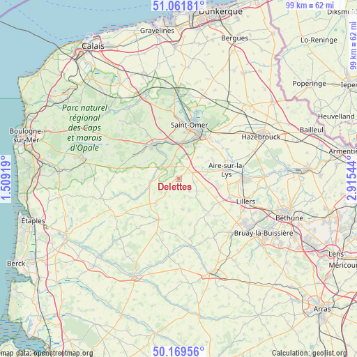
Delettes GPS coordinates[2]
50° 37' 4.08" North, 2° 12' 44.316" East
| Map corner | latitude | longitude |
|---|---|---|
| Upper-left | 51.06181°, | 1.50919° |
| Center: | 50.6178°, | 2.21231° |
| Lower-right: | 50.16956°, | 2.91544° |
| Map W x H: | 99.2×99.2 km | = 61.6×61.6mi |
| max Lat: | 51.07786° ⇑1.8% North |
| Delettes: | 50.6178° |
| min Lat: | ⇓98.2% South 41.3874° |
| min Long | Delettes | max Long |
| -5.08615° | 2.21231° | 9.52242° |
| W 45.8%⇐ | ⇒54.2% E |
Elevation
Elevation of Delettes is 43 m = 141 ft, and this is 150.7 m = 494 ft below average elevation for this country.
| Max E: |
2333 m = 7654 ft | 84.5% |
| Avg. | 193.7 m = 635 ft | |
| Delettes | 43 m = 141 ft | |
Min E: |
-1 m = -3 ft | 15.5% |
See also: France elevation on elevation.city.
Geographical zone
Delettes is located in North temperate zone (between Tropic of Cancer and the Arctic Circle). Distance of this North polar circle is 1773 km =1101.7 mi to North.| Distance of | km | miles | from Delettes |
|---|---|---|---|
| North Pole | 4378.9 | 2720.9 | to North |
| Arctic Circle | 1773 | 1101.7 | to North |
| Tropic Cancer | 3022.3 | 1878 | to South |
| Equator | 5628.2 | 3497.2 | to South |


Nearby cities:
15 places around Delettes: (largest is in red/bold)
• Audincthun
6.8 km =4.2 mi,  235°
235°
• Avroult
4.9 km =3 mi,  290°
290°
• Bomy
5.2 km =3.2 mi,  162°
162°
• Cléty
4.4 km =2.7 mi,  334°
334°
• Coyecques
2.6 km =1.6 mi,  232°
232°
• Dohem
3 km =1.9 mi,  321°
321°
• Ecques
7.8 km =4.8 mi,  41°
41°
• Enquin-les-Mines
6 km =3.7 mi,  124°
124°
• Estrée-Blanche
8.1 km =5 mi,  109°
109°
• Fauquembergues
8.2 km =5.1 mi,  256°
256°
• Mametz
8.2 km =5.1 mi,  76°
76°
• Merck-Saint-Liévin
6.8 km =4.2 mi,  276°
276°
• Ouve-Wirquin
6.3 km =3.9 mi,  302°
302°
• Pihem
7.3 km =4.5 mi,  0°
0°
• Thérouanne
3.9 km =2.4 mi,  56°
56°
Sources, notices
• [Note1] Compared only with cities in France existing in our database
• [Src1] Map data: © OpenStreetMap contributors (CC-BY-SA)
• [Src2] Other city data from geonames.org with taken over terms of usage.
• [Src3] Geographical zone / Annual Mean Temperature by Robert A. Rohde @ Wikipedia
