Merck-Saint-Liévin geodata
Merck-Saint-Liévin (Hauts-de-France) is a populated place; located in France in Europe/Paris (GMT+2) time zone. With population of 517 people, there are 14885 cities with bigger population in this country. Compared to other cities in France, 98.3% of cities are located further ↓South; 55.6% of cities are located further →East and 75.4% of cities have higher elevation than Merck-Saint-Liévin. Note1
Administrative division(s):
- Level 1: Hauts-de-France
- Level 2: Pas-de-Calais
- Level 3: Arrondissement de Saint-Omer
- Level 4: Merck-Saint-Liévin


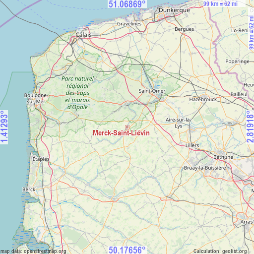
Merck-Saint-Liévin GPS coordinates[2]
50° 37' 29.064" North, 2° 6' 57.78" East
| Map corner | latitude | longitude |
|---|---|---|
| Upper-left | 51.06869°, | 1.41293° |
| Center: | 50.62474°, | 2.11605° |
| Lower-right: | 50.17656°, | 2.81918° |
| Map W x H: | 99.2×99.2 km | = 61.6×61.6mi |
| max Lat: | 51.07786° ⇑1.7% North |
| Merck-Saint-Liévin: | 50.62474° |
| min Lat: | ⇓98.3% South 41.3874° |
| min Long | Merck-Saint-Li� | max Long |
| -5.08615° | 2.11605° | 9.52242° |
| W 44.4%⇐ | ⇒55.6% E |
Elevation
Elevation of Merck-Saint-Liévin is 66 m = 217 ft, and this is 127.7 m = 419 ft below average elevation for this country.
| Max E: |
2333 m = 7654 ft | 75.4% |
| Avg. | 193.7 m = 635 ft | |
| Merck-Saint-Liévin | 66 m = 217 ft | |
Min E: |
-1 m = -3 ft | 24.6% |
See also: France elevation on elevation.city.
Geographical zone
Merck-Saint-Liévin is located in North temperate zone (between Tropic of Cancer and the Arctic Circle). Distance of this North polar circle is 1772.2 km =1101.2 mi to North.| Distance of | km | miles | from Merck-Saint-Liévin |
|---|---|---|---|
| North Pole | 4378.1 | 2720.4 | to North |
| Arctic Circle | 1772.2 | 1101.2 | to North |
| Tropic Cancer | 3023 | 1878.4 | to South |
| Equator | 5628.9 | 3497.6 | to South |


Nearby cities:
15 places around Merck-Saint-Liévin: (largest is in red/bold)
• Audincthun
4.8 km =3 mi,  165°
165°
• Avroult
2.4 km =1.5 mi,  67°
67°
• Campagne-lès-Boulonnais
8.6 km =5.3 mi,  261°
261°
• Cléty
5.9 km =3.7 mi,  56°
56°
• Coyecques
5.3 km =3.3 mi,  116°
116°
• Delettes
6.8 km =4.2 mi,  96°
96°
• Dohem
5.2 km =3.2 mi, 72°
• Elnes
7.2 km =4.5 mi,  5°
5°
• Fauquembergues
3 km =1.9 mi,  204°
204°
• Lumbres
9.1 km =5.7 mi,  2°
2°
• Nielles-lès-Bléquin
8.1 km =5 mi,  312°
312°
• Ouve-Wirquin
3 km =1.9 mi,  29°
29°
• Thiembronne
4.1 km =2.5 mi, 264°
• Verchocq
8.6 km =5.3 mi,  218°
218°
• Wismes
4.6 km =2.9 mi,  315°
315°
Sources, notices
• [Note1] Compared only with cities in France existing in our database
• [Src1] Map data: © OpenStreetMap contributors (CC-BY-SA)
• [Src2] Other city data from geonames.org with taken over terms of usage.
• [Src3] Geographical zone / Annual Mean Temperature by Robert A. Rohde @ Wikipedia
