Ouve-Wirquin geodata
Ouve-Wirquin (Hauts-de-France) is a populated place; located in France in Europe/Paris (GMT+2) time zone. With population of 506 people, there are 15128 cities with bigger population in this country. Compared to other cities in France, 98.4% of cities are located further ↓South; 55.3% of cities are located further →East and 77.8% of cities have higher elevation than Ouve-Wirquin. Note1
Administrative division(s):
- Level 1: Hauts-de-France
- Level 2: Pas-de-Calais
- Level 3: Arrondissement de Saint-Omer
- Level 4: Ouve-Wirquin


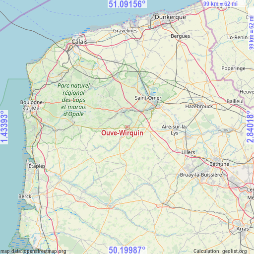
Ouve-Wirquin GPS coordinates[2]
50° 38' 52.188" North, 2° 8' 13.416" East
| Map corner | latitude | longitude |
|---|---|---|
| Upper-left | 51.09156°, | 1.43393° |
| Center: | 50.64783°, | 2.13706° |
| Lower-right: | 50.19987°, | 2.84018° |
| Map W x H: | 99.1×99.1 km | = 61.6×61.6mi |
| max Lat: | 51.07786° ⇑1.6% North |
| Ouve-Wirquin: | 50.64783° |
| min Lat: | ⇓98.4% South 41.3874° |
| min Long | Ouve-Wirquin | max Long |
| -5.08615° | 2.13706° | 9.52242° |
| W 44.7%⇐ | ⇒55.3% E |
Elevation
Elevation of Ouve-Wirquin is 60 m = 197 ft, and this is 133.7 m = 439 ft below average elevation for this country.
| Max E: |
2333 m = 7654 ft | 77.8% |
| Avg. | 193.7 m = 635 ft | |
| Ouve-Wirquin | 60 m = 197 ft | |
Min E: |
-1 m = -3 ft | 22.2% |
See also: France elevation on elevation.city.
Geographical zone
Ouve-Wirquin is located in North temperate zone (between Tropic of Cancer and the Arctic Circle). Distance of this North polar circle is 1769.7 km =1099.6 mi to North.| Distance of | km | miles | from Ouve-Wirquin |
|---|---|---|---|
| North Pole | 4375.6 | 2718.9 | to North |
| Arctic Circle | 1769.7 | 1099.6 | to North |
| Tropic Cancer | 3025.6 | 1880 | to South |
| Equator | 5631.5 | 3499.3 | to South |


Nearby cities:
15 places around Ouve-Wirquin: (largest is in red/bold)
• Audincthun
7.2 km =4.5 mi,  182°
182°
• Avroult
1.8 km =1.1 mi,  156°
156°
• Cléty
3.5 km =2.2 mi,  79°
79°
• Coyecques
5.9 km =3.7 mi,  146°
146°
• Delettes
6.3 km =3.9 mi,  122°
122°
• Dohem
3.6 km =2.2 mi,  105°
105°
• Elnes
4.7 km =2.9 mi,  350°
350°
• Esquerdes
7.2 km =4.5 mi,  30°
30°
• Fauquembergues
5.9 km =3.7 mi,  207°
207°
• Lumbres
6.7 km =4.2 mi, 350°
• Merck-Saint-Liévin
3 km =1.9 mi, 209°
• Pihem
6.7 km =4.2 mi,  54°
54°
• Setques
7.3 km =4.5 mi,  12°
12°
• Thiembronne
6.3 km =3.9 mi,  241°
241°
• Wismes
4.7 km =2.9 mi,  278°
278°
Sources, notices
• [Note1] Compared only with cities in France existing in our database
• [Src1] Map data: © OpenStreetMap contributors (CC-BY-SA)
• [Src2] Other city data from geonames.org with taken over terms of usage.
• [Src3] Geographical zone / Annual Mean Temperature by Robert A. Rohde @ Wikipedia
