Thérouanne geodata
Thérouanne (Hauts-de-France) is a populated place; located in France in Europe/Paris (GMT+2) time zone. With population of 1,074 people, there are 8304 cities with bigger population in this country. Compared to other cities in France, 98.4% of cities are located further ↓South; 53.4% of cities are located further →East and 87.4% of cities have higher elevation than Thérouanne. Note1
Administrative division(s):
- Level 1: Hauts-de-France
- Level 2: Pas-de-Calais
- Level 3: Arrondissement de Saint-Omer
- Level 4: Thérouanne


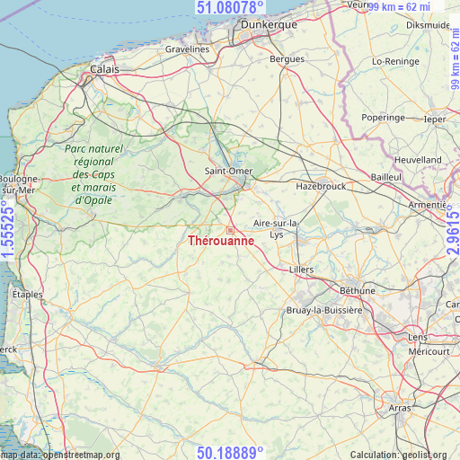
Thérouanne GPS coordinates[2]
50° 38' 13.02" North, 2° 15' 30.168" East
| Map corner | latitude | longitude |
|---|---|---|
| Upper-left | 51.08078°, | 1.55525° |
| Center: | 50.63695°, | 2.25838° |
| Lower-right: | 50.18889°, | 2.9615° |
| Map W x H: | 99.2×99.2 km | = 61.6×61.6mi |
| max Lat: | 51.07786° ⇑1.6% North |
| Thérouanne: | 50.63695° |
| min Lat: | ⇓98.4% South 41.3874° |
| min Long | Thérouanne | max Long |
| -5.08615° | 2.25838° | 9.52242° |
| W 46.6%⇐ | ⇒53.4% E |
Elevation
Elevation of Thérouanne is 36 m = 118 ft, and this is 157.7 m = 517 ft below average elevation for this country.
| Max E: |
2333 m = 7654 ft | 87.4% |
| Avg. | 193.7 m = 635 ft | |
| Thérouanne | 36 m = 118 ft | |
Min E: |
-1 m = -3 ft | 12.6% |
See also: France elevation on elevation.city.
Geographical zone
Thérouanne is located in North temperate zone (between Tropic of Cancer and the Arctic Circle). Distance of this North polar circle is 1770.9 km =1100.4 mi to North.| Distance of | km | miles | from Thérouanne |
|---|---|---|---|
| North Pole | 4376.8 | 2719.6 | to North |
| Arctic Circle | 1770.9 | 1100.4 | to North |
| Tropic Cancer | 3024.4 | 1879.3 | to South |
| Equator | 5630.3 | 3498.5 | to South |


Nearby cities:
15 places around Thérouanne: (largest is in red/bold)
• Blessy
5.7 km =3.5 mi,  113°
113°
• Bomy
7.2 km =4.5 mi,  193°
193°
• Cléty
5.4 km =3.4 mi,  289°
289°
• Coyecques
6.5 km =4 mi,  235°
235°
• Delettes
3.9 km =2.4 mi, 236°
• Dohem
5.1 km =3.2 mi,  272°
272°
• Ecques
4.2 km =2.6 mi,  28°
28°
• Enquin-les-Mines
5.8 km =3.6 mi,  162°
162°
• Estrée-Blanche
6.5 km =4 mi,  137°
137°
• Helfaut
6.9 km =4.3 mi,  350°
350°
• Heuringhem
6.8 km =4.2 mi,  14°
14°
• Mametz
4.7 km =2.9 mi,  92°
92°
• Pihem
6 km =3.7 mi,  328°
328°
• Quiestède
7.2 km =4.5 mi,  47°
47°
• Roquetoire
7 km =4.3 mi,  58°
58°
Sources, notices
• [Note1] Compared only with cities in France existing in our database
• [Src1] Map data: © OpenStreetMap contributors (CC-BY-SA)
• [Src2] Other city data from geonames.org with taken over terms of usage.
• [Src3] Geographical zone / Annual Mean Temperature by Robert A. Rohde @ Wikipedia
