Coyecques geodata
Coyecques (Hauts-de-France) is a populated place; located in France in Europe/Paris (GMT+2) time zone. With population of 577 people, there are 13707 cities with bigger population in this country. Compared to other cities in France, 98.1% of cities are located further ↓South; 54.7% of cities are located further →East and 82.2% of cities have higher elevation than Coyecques. Note1
Administrative division(s):
- Level 1: Hauts-de-France
- Level 2: Pas-de-Calais
- Level 3: Arrondissement de Saint-Omer
- Level 4: Coyecques


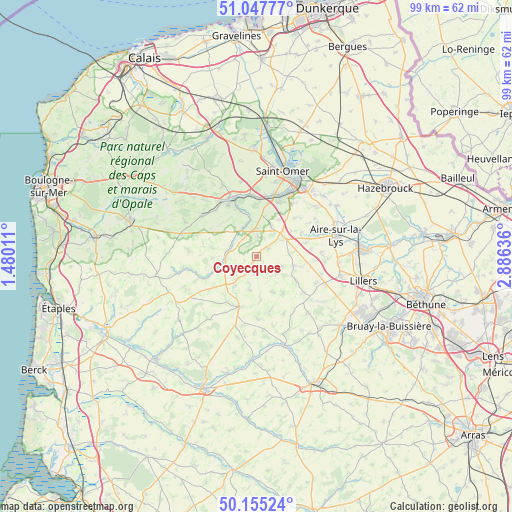
Coyecques GPS coordinates[2]
50° 36' 13.032" North, 2° 10' 59.628" East
| Map corner | latitude | longitude |
|---|---|---|
| Upper-left | 51.04777°, | 1.48011° |
| Center: | 50.60362°, | 2.18323° |
| Lower-right: | 50.15524°, | 2.88636° |
| Map W x H: | 99.2×99.2 km | = 61.6×61.6mi |
| max Lat: | 51.07786° ⇑1.9% North |
| Coyecques: | 50.60362° |
| min Lat: | ⇓98.1% South 41.3874° |
| min Long | Coyecques | max Long |
| -5.08615° | 2.18323° | 9.52242° |
| W 45.3%⇐ | ⇒54.7% E |
Elevation
Elevation of Coyecques is 49 m = 161 ft, and this is 144.7 m = 475 ft below average elevation for this country.
| Max E: |
2333 m = 7654 ft | 82.2% |
| Avg. | 193.7 m = 635 ft | |
| Coyecques | 49 m = 161 ft | |
Min E: |
-1 m = -3 ft | 17.8% |
See also: France elevation on elevation.city.
Geographical zone
Coyecques is located in North temperate zone (between Tropic of Cancer and the Arctic Circle). Distance of this North polar circle is 1774.6 km =1102.7 mi to North.| Distance of | km | miles | from Coyecques |
|---|---|---|---|
| North Pole | 4380.5 | 2721.9 | to North |
| Arctic Circle | 1774.6 | 1102.7 | to North |
| Tropic Cancer | 3020.7 | 1877 | to South |
| Equator | 5626.6 | 3496.2 | to South |


Nearby cities:
15 places around Coyecques: (largest is in red/bold)
• Audincthun
4.2 km =2.6 mi,  237°
237°
• Avroult
4.1 km =2.5 mi,  321°
321°
• Bomy
4.9 km =3 mi,  132°
132°
• Cléty
5.5 km =3.4 mi,  1°
1°
• Delettes
2.6 km =1.6 mi,  52°
52°
• Dohem
3.9 km =2.4 mi, 2°
• Enquin-les-Mines
7.3 km =4.5 mi,  104°
104°
• Estrée-Blanche
9.7 km =6 mi, 96°
• Fauquembergues
6 km =3.7 mi,  266°
266°
• Merck-Saint-Liévin
5.3 km =3.3 mi,  296°
296°
• Ouve-Wirquin
5.9 km =3.7 mi,  326°
326°
• Pihem
9.1 km =5.7 mi,  13°
13°
• Thiembronne
9 km =5.6 mi,  282°
282°
• Thérouanne
6.5 km =4 mi,  55°
55°
• Wismes
9.7 km =6 mi,  305°
305°
Sources, notices
• [Note1] Compared only with cities in France existing in our database
• [Src1] Map data: © OpenStreetMap contributors (CC-BY-SA)
• [Src2] Other city data from geonames.org with taken over terms of usage.
• [Src3] Geographical zone / Annual Mean Temperature by Robert A. Rohde @ Wikipedia
