Damazan geodata
Damazan (Nouvelle-Aquitaine) is a populated place; located in France in Europe/Paris (GMT+2) time zone. With population of 1,386 people, there are 6664 cities with bigger population in this country. Compared to other cities in France, 84.9% of cities are located further ↑North; 75.5% of cities are located further →East and 79.4% of cities have higher elevation than Damazan. Note1
Administrative division(s):
- Level 1: Nouvelle-Aquitaine
- Level 2: Département du Lot-et-Garonne
- Level 3: Arrondissement de Nérac
- Level 4: Damazan


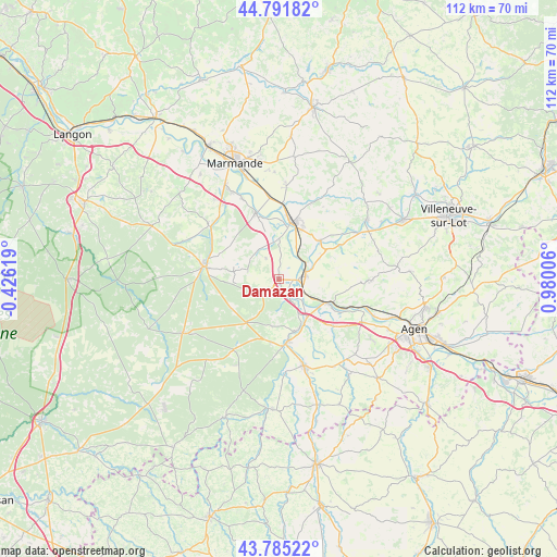
Damazan GPS coordinates[2]
44° 17' 26.448" North, 0° 16' 36.984" East
| Map corner | latitude | longitude |
|---|---|---|
| Upper-left | 44.79182°, | -0.42619° |
| Center: | 44.29068°, | 0.27694° |
| Lower-right: | 43.78522°, | 0.98006° |
| Map W x H: | 111.9×111.9 km | = 69.5×69.5mi |
| max Lat: | 51.07786° ⇑84.9% North |
| Damazan: | 44.29068° |
| min Lat: | ⇓15.1% South 41.3874° |
| min Long | Damazan | max Long |
| -5.08615° | 0.27694° | 9.52242° |
| W 24.5%⇐ | ⇒75.5% E |
Elevation
Elevation of Damazan is 56 m = 184 ft, and this is 137.7 m = 452 ft below average elevation for this country.
| Max E: |
2333 m = 7654 ft | 79.4% |
| Avg. | 193.7 m = 635 ft | |
| Damazan | 56 m = 184 ft | |
Min E: |
-1 m = -3 ft | 20.6% |
See also: France elevation on elevation.city.
Geographical zone
Damazan is located in North temperate zone (between Tropic of Cancer and the Arctic Circle). Distance of this Northern Tropic circle is 2318.7 km =1440.8 mi to South.| Distance of | km | miles | from Damazan |
|---|---|---|---|
| North Pole | 5082.4 | 3158.1 | to North |
| Arctic Circle | 2476.5 | 1538.8 | to North |
| Tropic Cancer | 2318.7 | 1440.8 | to South |
| Equator | 4924.7 | 3060.1 | to South |


Nearby cities:
15 places around Damazan: (largest is in red/bold)
• Aiguillon
5.1 km =3.2 mi,  79°
79°
• Barbaste
13.5 km =8.4 mi,  176°
176°
• Bazens
12 km =7.5 mi,  104°
104°
• Bourran
11 km =6.8 mi,  58°
58°
• Buzet-sur-Baïse
4 km =2.5 mi,  155°
155°
• Calonges
9.7 km =6 mi,  343°
343°
• Clairac
11.2 km =7 mi,  46°
46°
• Clermont-Dessous
11.9 km =7.4 mi,  113°
113°
• Feugarolles
9.5 km =5.9 mi,  143°
143°
• Lafitte-sur-Lot
14 km =8.7 mi, 61°
• Lavardac
12.7 km =7.9 mi,  172°
172°
• Port-Sainte-Marie
10.1 km =6.3 mi,  115°
115°
• Tonneins
11.6 km =7.2 mi,  14°
14°
• Vianne
11 km =6.8 mi, 161°
• Villeton
9.4 km =5.8 mi, 5°
Sources, notices
• [Note1] Compared only with cities in France existing in our database
• [Src1] Map data: © OpenStreetMap contributors (CC-BY-SA)
• [Src2] Other city data from geonames.org with taken over terms of usage.
• [Src3] Geographical zone / Annual Mean Temperature by Robert A. Rohde @ Wikipedia
