Bourran geodata
Bourran (Nouvelle-Aquitaine) is a populated place; located in France in Europe/Paris (GMT+2) time zone. With population of 609 people, there are 13174 cities with bigger population in this country. Compared to other cities in France, 84.6% of cities are located further ↑North; 74.4% of cities are located further →East and 88.3% of cities have higher elevation than Bourran. Note1
Administrative division(s):
- Level 1: Nouvelle-Aquitaine
- Level 2: Département du Lot-et-Garonne
- Level 3: Agen
- Level 4: Bourran


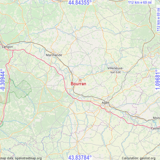
Bourran GPS coordinates[2]
44° 20' 34.26" North, 0° 23' 37.284" East
| Map corner | latitude | longitude |
|---|---|---|
| Upper-left | 44.84355°, | -0.30944° |
| Center: | 44.34285°, | 0.39369° |
| Lower-right: | 43.83784°, | 1.09681° |
| Map W x H: | 111.8×111.8 km | = 69.5×69.5mi |
| max Lat: | 51.07786° ⇑84.6% North |
| Bourran: | 44.34285° |
| min Lat: | ⇓15.4% South 41.3874° |
| min Long | Bourran | max Long |
| -5.08615° | 0.39369° | 9.52242° |
| W 25.6%⇐ | ⇒74.4% E |
Elevation
Elevation of Bourran is 34 m = 112 ft, and this is 159.7 m = 524 ft below average elevation for this country.
| Max E: |
2333 m = 7654 ft | 88.3% |
| Avg. | 193.7 m = 635 ft | |
| Bourran | 34 m = 112 ft | |
Min E: |
-1 m = -3 ft | 11.7% |
See also: France elevation on elevation.city.
Geographical zone
Bourran is located in North temperate zone (between Tropic of Cancer and the Arctic Circle). Distance of this Northern Tropic circle is 2324.5 km =1444.4 mi to South.| Distance of | km | miles | from Bourran |
|---|---|---|---|
| North Pole | 5076.6 | 3154.5 | to North |
| Arctic Circle | 2470.7 | 1535.2 | to North |
| Tropic Cancer | 2324.5 | 1444.4 | to South |
| Equator | 4930.5 | 3063.7 | to South |


Nearby cities:
15 places around Bourran: (largest is in red/bold)
• Aiguillon
6.5 km =4 mi,  221°
221°
• Bazens
9.2 km =5.7 mi,  165°
165°
• Castelmoron-sur-Lot
10.2 km =6.3 mi,  52°
52°
• Clairac
2.2 km =1.4 mi,  328°
328°
• Clermont-Dessous
10.6 km =6.6 mi, 171°
• Damazan
11 km =6.8 mi,  238°
238°
• Granges-sur-Lot
6.8 km =4.2 mi,  56°
56°
• Lafitte-sur-Lot
3.1 km =1.9 mi,  71°
71°
• Le Temple-sur-Lot
11.2 km =7 mi, 68°
• Montpezat
10.3 km =6.4 mi,  86°
86°
• Port-Sainte-Marie
10.1 km =6.3 mi,  181°
181°
• Prayssas
9.9 km =6.2 mi,  141°
141°
• Tonneins
8.5 km =5.3 mi,  310°
310°
• Varès
10 km =6.2 mi,  344°
344°
• Villeton
9.1 km =5.7 mi,  292°
292°
Sources, notices
• [Note1] Compared only with cities in France existing in our database
• [Src1] Map data: © OpenStreetMap contributors (CC-BY-SA)
• [Src2] Other city data from geonames.org with taken over terms of usage.
• [Src3] Geographical zone / Annual Mean Temperature by Robert A. Rohde @ Wikipedia
