Aiguillon geodata
Aiguillon (Nouvelle-Aquitaine) is a populated place; located in France in Europe/Paris (GMT+2) time zone. With population of 4,576 people, there are 2161 cities with bigger population in this country. Compared to other cities in France, 84.9% of cities are located further ↑North; 74.9% of cities are located further →East and 83.8% of cities have higher elevation than Aiguillon. Note1
Administrative division(s):
- Level 1: Nouvelle-Aquitaine
- Level 2: Département du Lot-et-Garonne
- Level 3: Agen
- Level 4: Aiguillon


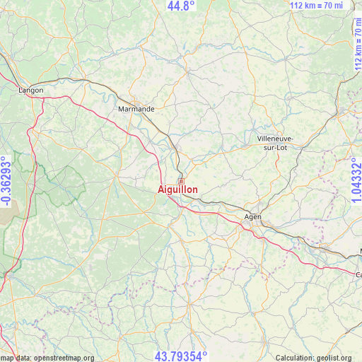
Aiguillon GPS coordinates[2]
44° 17' 56.148" North, 0° 20' 24.72" East
| Map corner | latitude | longitude |
|---|---|---|
| Upper-left | 44.8°, | -0.36293° |
| Center: | 44.29893°, | 0.3402° |
| Lower-right: | 43.79354°, | 1.04332° |
| Map W x H: | 111.9×111.9 km | = 69.5×69.5mi |
| max Lat: | 51.07786° ⇑84.9% North |
| Aiguillon: | 44.29893° |
| min Lat: | ⇓15.1% South 41.3874° |
| min Long | Aiguillon | max Long |
| -5.08615° | 0.3402° | 9.52242° |
| W 25.1%⇐ | ⇒74.9% E |
Elevation
Elevation of Aiguillon is 45 m = 148 ft, and this is 148.7 m = 488 ft below average elevation for this country.
| Max E: |
2333 m = 7654 ft | 83.8% |
| Avg. | 193.7 m = 635 ft | |
| Aiguillon | 45 m = 148 ft | |
Min E: |
-1 m = -3 ft | 16.2% |
See also: France elevation on elevation.city.
Geographical zone
Aiguillon is located in North temperate zone (between Tropic of Cancer and the Arctic Circle). Distance of this Northern Tropic circle is 2319.7 km =1441.4 mi to South.| Distance of | km | miles | from Aiguillon |
|---|---|---|---|
| North Pole | 5081.5 | 3157.5 | to North |
| Arctic Circle | 2475.6 | 1538.3 | to North |
| Tropic Cancer | 2319.7 | 1441.4 | to South |
| Equator | 4925.6 | 3060.6 | to South |


Nearby cities:
15 places around Aiguillon: (largest is in red/bold)
• Bazens
7.7 km =4.8 mi,  121°
121°
• Bourran
6.5 km =4 mi,  41°
41°
• Bruch
11.9 km =7.4 mi,  151°
151°
• Buzet-sur-Baïse
5.6 km =3.5 mi,  216°
216°
• Calonges
11.5 km =7.1 mi,  316°
316°
• Clairac
7.5 km =4.7 mi,  24°
24°
• Clermont-Dessous
8.1 km =5 mi,  133°
133°
• Damazan
5.1 km =3.2 mi,  259°
259°
• Feugarolles
8.6 km =5.3 mi,  176°
176°
• Lafitte-sur-Lot
9.3 km =5.8 mi,  50°
50°
• Port-Sainte-Marie
6.7 km =4.2 mi,  142°
142°
• Prayssas
10.8 km =6.7 mi,  105°
105°
• Tonneins
10.6 km =6.6 mi,  347°
347°
• Vianne
11.5 km =7.1 mi,  187°
187°
• Villeton
9.4 km =5.8 mi,  333°
333°
Sources, notices
• [Note1] Compared only with cities in France existing in our database
• [Src1] Map data: © OpenStreetMap contributors (CC-BY-SA)
• [Src2] Other city data from geonames.org with taken over terms of usage.
• [Src3] Geographical zone / Annual Mean Temperature by Robert A. Rohde @ Wikipedia
