Tonneins geodata
Tonneins (Nouvelle-Aquitaine) is a populated place; located in France in Europe/Paris (GMT+2) time zone. With population of 9,823 people, there are 968 cities with bigger population in this country. Compared to other cities in France, 84.3% of cities are located further ↑North; 75.3% of cities are located further →East and 84.9% of cities have higher elevation than Tonneins. Note1
Administrative division(s):
- Level 1: Nouvelle-Aquitaine
- Level 2: Département du Lot-et-Garonne
- Level 3: Arrondissement de Marmande
- Level 4: Tonneins


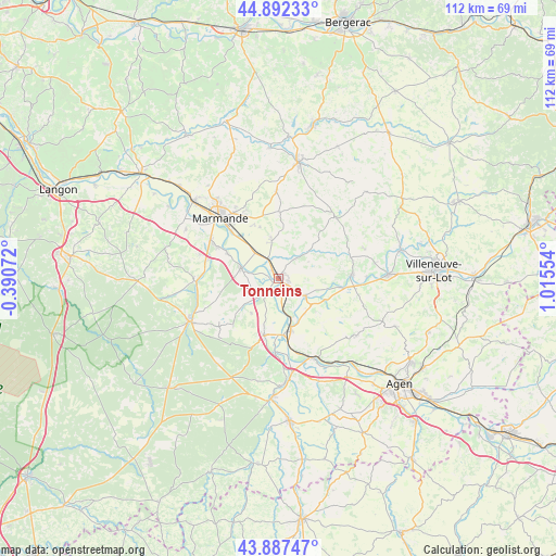
Tonneins GPS coordinates[2]
44° 23' 31.416" North, 0° 18' 44.676" East
| Map corner | latitude | longitude |
|---|---|---|
| Upper-left | 44.89233°, | -0.39072° |
| Center: | 44.39206°, | 0.31241° |
| Lower-right: | 43.88747°, | 1.01554° |
| Map W x H: | 111.7×111.7 km | = 69.4×69.4mi |
| max Lat: | 51.07786° ⇑84.3% North |
| Tonneins: | 44.39206° |
| min Lat: | ⇓15.7% South 41.3874° |
| min Long | Tonneins | max Long |
| -5.08615° | 0.31241° | 9.52242° |
| W 24.7%⇐ | ⇒75.3% E |
Elevation
Elevation of Tonneins is 42 m = 138 ft, and this is 151.7 m = 498 ft below average elevation for this country.
| Max E: |
2333 m = 7654 ft | 84.9% |
| Avg. | 193.7 m = 635 ft | |
| Tonneins | 42 m = 138 ft | |
Min E: |
-1 m = -3 ft | 15.1% |
See also: France elevation on elevation.city.
Geographical zone
Tonneins is located in North temperate zone (between Tropic of Cancer and the Arctic Circle). Distance of this Northern Tropic circle is 2330 km =1447.8 mi to South.| Distance of | km | miles | from Tonneins |
|---|---|---|---|
| North Pole | 5071.1 | 3151 | to North |
| Arctic Circle | 2465.2 | 1531.8 | to North |
| Tropic Cancer | 2330 | 1447.8 | to South |
| Equator | 4935.9 | 3067 | to South |


Nearby cities:
15 places around Tonneins: (largest is in red/bold)
• Aiguillon
10.6 km =6.6 mi,  167°
167°
• Birac-sur-Trec
11 km =6.8 mi,  340°
340°
• Bourran
8.5 km =5.3 mi,  130°
130°
• Calonges
5.9 km =3.7 mi,  250°
250°
• Caumont-sur-Garonne
11.6 km =7.2 mi,  296°
296°
• Clairac
6.4 km =4 mi,  123°
123°
• Damazan
11.6 km =7.2 mi,  194°
194°
• Fauguerolles
7.5 km =4.7 mi,  318°
318°
• Fauillet
4.2 km =2.6 mi, 335°
• Gontaud-de-Nogaret
6.5 km =4 mi,  351°
351°
• Granges-sur-Lot
12.3 km =7.6 mi,  98°
98°
• Lafitte-sur-Lot
10.4 km =6.5 mi, 115°
• Le Mas-d’Agenais
7.7 km =4.8 mi,  285°
285°
• Varès
5.6 km =3.5 mi,  41°
41°
• Villeton
2.7 km =1.7 mi,  225°
225°
Sources, notices
• [Note1] Compared only with cities in France existing in our database
• [Src1] Map data: © OpenStreetMap contributors (CC-BY-SA)
• [Src2] Other city data from geonames.org with taken over terms of usage.
• [Src3] Geographical zone / Annual Mean Temperature by Robert A. Rohde @ Wikipedia
