Cuffy geodata
Cuffy (Centre) is a populated place; located in France in Europe/Paris (GMT+2) time zone. With population of 1,107 people, there are 8081 cities with bigger population in this country. Compared to other cities in France, 55.7% of cities are located further ↑North; 58.5% of cities are located further ←West and 63.1% of cities have lower elevation than Cuffy. Note1
Administrative division(s):
- Level 1: Centre
- Level 2: Cher
- Level 3: Arrondissement de Saint-Amand-Montrond
- Level 4: Cuffy


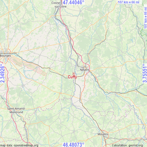
Cuffy GPS coordinates[2]
46° 57' 45.9" North, 3° 3' 8.568" East
| Map corner | latitude | longitude |
|---|---|---|
| Upper-left | 47.44046°, | 2.34926° |
| Center: | 46.96275°, | 3.05238° |
| Lower-right: | 46.48073°, | 3.75551° |
| Map W x H: | 106.7×106.7 km | = 66.3×66.3mi |
| max Lat: | 51.07786° ⇑55.7% North |
| Cuffy: | 46.96275° |
| min Lat: | ⇓44.3% South 41.3874° |
| min Long | Cuffy | max Long |
| -5.08615° | 3.05238° | 9.52242° |
| W 58.5%⇐ | ⇒41.5% E |
Elevation
Elevation of Cuffy is 185 m = 607 ft, and this is 8.7 m = 29 ft below average elevation for this country.
| Max E: |
2333 m = 7654 ft | 36.9% |
| Avg. | 193.7 m = 635 ft | |
| Cuffy | 185 m = 607 ft | |
Min E: |
-1 m = -3 ft | 63.1% |
See also: France elevation on elevation.city.
Geographical zone
Cuffy is located in North temperate zone (between Tropic of Cancer and the Arctic Circle). Distance of this North polar circle is 2179.4 km =1354.2 mi to North.| Distance of | km | miles | from Cuffy |
|---|---|---|---|
| North Pole | 4785.3 | 2973.4 | to North |
| Arctic Circle | 2179.4 | 1354.2 | to North |
| Tropic Cancer | 2615.8 | 1625.4 | to South |
| Equator | 5221.8 | 3244.7 | to South |


Nearby cities:
15 places around Cuffy: (largest is in red/bold)
• Challuy
7.4 km =4.6 mi,  101°
101°
• Coulanges-lès-Nevers
11.3 km =7 mi,  65°
65°
• Cours-les-Barres
7.1 km =4.4 mi,  347°
347°
• Fourchambault
6.4 km =4 mi,  21°
21°
• Garchizy
10 km =6.2 mi, 19°
• Gimouille
3.4 km =2.1 mi,  131°
131°
• Jouet-sur-l'Aubois
10.5 km =6.5 mi,  331°
331°
• Magny-Cours
11.5 km =7.1 mi,  139°
139°
• Marseilles-lès-Aubigny
12 km =7.5 mi, 345°
• Marzy
3.7 km =2.3 mi,  56°
56°
• Nevers
8.6 km =5.3 mi, 69°
• Saint-Éloi
12.9 km =8 mi,  84°
84°
• Sermoise-sur-Loire
10 km =6.2 mi, 98°
• Torteron
9.3 km =5.8 mi,  315°
315°
• Varennes-Vauzelles
9 km =5.6 mi,  48°
48°
Sources, notices
• [Note1] Compared only with cities in France existing in our database
• [Src1] Map data: © OpenStreetMap contributors (CC-BY-SA)
• [Src2] Other city data from geonames.org with taken over terms of usage.
• [Src3] Geographical zone / Annual Mean Temperature by Robert A. Rohde @ Wikipedia
