Fourchambault geodata
Fourchambault (Bourgogne-Franche-Comté) is a populated place; located in France in Europe/Paris (GMT+2) time zone. With population of 4,874 people, there are 2037 cities with bigger population in this country. Compared to other cities in France, 55.1% of cities are located further ↑North; 59% of cities are located further ←West and 62.1% of cities have lower elevation than Fourchambault. Note1
Administrative division(s):
- Level 1: Bourgogne-Franche-Comté
- Level 2: Département de la Nièvre
- Level 3: Arrondissement de Nevers
- Level 4: Fourchambault


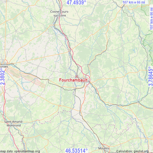
Fourchambault GPS coordinates[2]
47° 1' 0.012" North, 3° 4' 59.988" East
| Map corner | latitude | longitude |
|---|---|---|
| Upper-left | 47.4939°, | 2.3802° |
| Center: | 47.01667°, | 3.08333° |
| Lower-right: | 46.53514°, | 3.78645° |
| Map W x H: | 106.6×106.6 km | = 66.2×66.2mi |
| max Lat: | 51.07786° ⇑55.1% North |
| Fourchambault: | 47.01667° |
| min Lat: | ⇓44.9% South 41.3874° |
| min Long | Fourchambault | max Long |
| -5.08615° | 3.08333° | 9.52242° |
| W 59%⇐ | ⇒41% E |
Elevation
Elevation of Fourchambault is 180 m = 591 ft, and this is 13.7 m = 45 ft below average elevation for this country.
| Max E: |
2333 m = 7654 ft | 37.9% |
| Avg. | 193.7 m = 635 ft | |
| Fourchambault | 180 m = 591 ft | |
Min E: |
-1 m = -3 ft | 62.1% |
See also: France elevation on elevation.city.
Geographical zone
Fourchambault is located in North temperate zone (between Tropic of Cancer and the Arctic Circle). Distance of this North polar circle is 2173.4 km =1350.5 mi to North.| Distance of | km | miles | from Fourchambault |
|---|---|---|---|
| North Pole | 4779.3 | 2969.7 | to North |
| Arctic Circle | 2173.4 | 1350.5 | to North |
| Tropic Cancer | 2621.8 | 1629.1 | to South |
| Equator | 5227.8 | 3248.4 | to South |


Nearby cities:
15 places around Fourchambault: (largest is in red/bold)
• Challuy
8.9 km =5.5 mi,  146°
146°
• Coulanges-lès-Nevers
8 km =5 mi,  99°
99°
• Cours-les-Barres
4 km =2.5 mi,  283°
283°
• Cuffy
6.4 km =4 mi,  201°
201°
• Garchizy
3.6 km =2.2 mi,  15°
15°
• Germigny-sur-Loire
8.3 km =5.2 mi,  332°
332°
• Gimouille
8.3 km =5.2 mi,  178°
178°
• Jouet-sur-l'Aubois
8 km =5 mi,  293°
293°
• Marseilles-lès-Aubigny
7.8 km =4.8 mi,  315°
315°
• Marzy
4 km =2.5 mi,  168°
168°
• Nevers
6.5 km =4 mi,  117°
117°
• Parigny-les-Vaux
9.7 km =6 mi,  30°
30°
• Pougues-les-Eaux
6.6 km =4.1 mi,  11°
11°
• Torteron
8.9 km =5.5 mi,  274°
274°
• Varennes-Vauzelles
4.3 km =2.7 mi,  89°
89°
Sources, notices
• [Note1] Compared only with cities in France existing in our database
• [Src1] Map data: © OpenStreetMap contributors (CC-BY-SA)
• [Src2] Other city data from geonames.org with taken over terms of usage.
• [Src3] Geographical zone / Annual Mean Temperature by Robert A. Rohde @ Wikipedia
