Varennes-Vauzelles geodata
Varennes-Vauzelles (Bourgogne-Franche-Comté) is a populated place; located in France in Europe/Paris (GMT+2) time zone. With population of 10,464 people, there are 909 cities with bigger population in this country. Compared to other cities in France, 55.1% of cities are located further ↑North; 59.8% of cities are located further ←West and 70.1% of cities have lower elevation than Varennes-Vauzelles. Note1
Administrative division(s):
- Level 1: Bourgogne-Franche-Comté
- Level 2: Département de la Nièvre
- Level 3: Arrondissement de Nevers
- Level 4: Varennes-Vauzelles


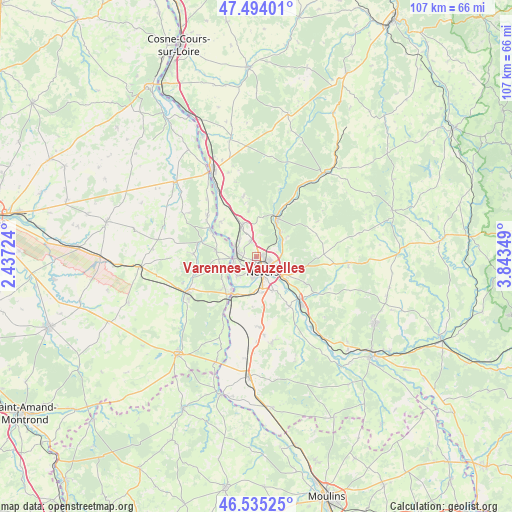
Varennes-Vauzelles GPS coordinates[2]
47° 1' 0.408" North, 3° 8' 25.332" East
| Map corner | latitude | longitude |
|---|---|---|
| Upper-left | 47.49401°, | 2.43724° |
| Center: | 47.01678°, | 3.14037° |
| Lower-right: | 46.53525°, | 3.84349° |
| Map W x H: | 106.6×106.6 km | = 66.2×66.2mi |
| max Lat: | 51.07786° ⇑55.1% North |
| Varennes-Vauzelles: | 47.01678° |
| min Lat: | ⇓44.9% South 41.3874° |
| min Long | Varennes-Vauzel | max Long |
| -5.08615° | 3.14037° | 9.52242° |
| W 59.8%⇐ | ⇒40.2% E |
Elevation
Elevation of Varennes-Vauzelles is 220 m = 722 ft, and this is 26.3 m = 86 ft above average elevation for this country.
| Max E: |
2333 m = 7654 ft | 29.9% |
| Varennes-Vauzelles | 220 m 722 ft | |
| Avg. | 193.7 m = 635 ft | |
Min E: |
-1 m = -3 ft | 70.1% |
See also: France elevation on elevation.city.
Geographical zone
Varennes-Vauzelles is located in North temperate zone (between Tropic of Cancer and the Arctic Circle). Distance of this North polar circle is 2173.4 km =1350.5 mi to North.| Distance of | km | miles | from Varennes-Vauzelles |
|---|---|---|---|
| North Pole | 4779.3 | 2969.7 | to North |
| Arctic Circle | 2173.4 | 1350.5 | to North |
| Tropic Cancer | 2621.9 | 1629.2 | to South |
| Equator | 5227.8 | 3248.4 | to South |


Nearby cities:
15 places around Varennes-Vauzelles: (largest is in red/bold)
• Challuy
7.5 km =4.7 mi,  175°
175°
• Coulanges-lès-Nevers
3.8 km =2.4 mi,  109°
109°
• Cours-les-Barres
8.3 km =5.2 mi,  276°
276°
• Cuffy
9 km =5.6 mi,  228°
228°
• Fourchambault
4.3 km =2.7 mi,  269°
269°
• Garchizy
4.8 km =3 mi,  315°
315°
• Gimouille
9.3 km =5.8 mi,  206°
206°
• Guérigny
9.1 km =5.7 mi,  30°
30°
• Marzy
5.3 km =3.3 mi,  221°
221°
• Nevers
3.3 km =2.1 mi,  154°
154°
• Parigny-les-Vaux
8.3 km =5.2 mi,  4°
4°
• Pougues-les-Eaux
7.1 km =4.4 mi,  335°
335°
• Saint-Éloi
7.9 km =4.9 mi,  127°
127°
• Sermoise-sur-Loire
8.1 km =5 mi,  156°
156°
• Urzy
5.9 km =3.7 mi,  53°
53°
Sources, notices
• [Note1] Compared only with cities in France existing in our database
• [Src1] Map data: © OpenStreetMap contributors (CC-BY-SA)
• [Src2] Other city data from geonames.org with taken over terms of usage.
• [Src3] Geographical zone / Annual Mean Temperature by Robert A. Rohde @ Wikipedia
