Cruguel geodata
Cruguel (Brittany) is a populated place; located in France in Europe/Paris (GMT+2) time zone. With population of 636 people, there are 12726 cities with bigger population in this country. Compared to other cities in France, 57.2% of cities are located further ↓South; 96.5% of cities are located further →East and 53.9% of cities have lower elevation than Cruguel. Note1
Administrative division(s):
- Level 1: Brittany
- Level 2: Morbihan
- Level 3: Arrondissement de Pontivy
- Level 4: Cruguel


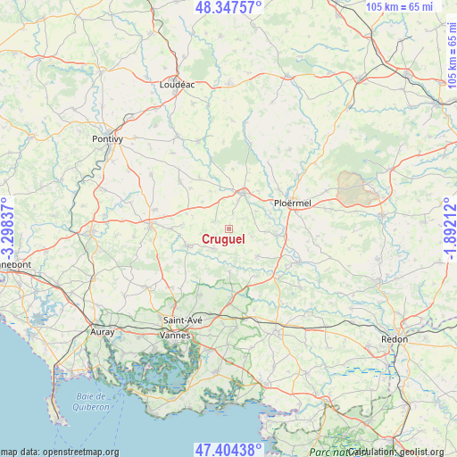
Cruguel GPS coordinates[2]
47° 52' 41.232" North, 2° 35' 42.9" West
| Map corner | latitude | longitude |
|---|---|---|
| Upper-left | 48.34757°, | -3.29837° |
| Center: | 47.87812°, | -2.59525° |
| Lower-right: | 47.40438°, | -1.89212° |
| Map W x H: | 104.9×104.9 km | = 65.2×65.2mi |
| max Lat: | 51.07786° ⇑42.8% North |
| Cruguel: | 47.87812° |
| min Lat: | ⇓57.2% South 41.3874° |
| min Long | Cruguel | max Long |
| -5.08615° | -2.59525° | 9.52242° |
| W 3.5%⇐ | ⇒96.5% E |
Elevation
Elevation of Cruguel is 146 m = 479 ft, and this is 47.7 m = 156 ft below average elevation for this country.
| Max E: |
2333 m = 7654 ft | 46.1% |
| Avg. | 193.7 m = 635 ft | |
| Cruguel | 146 m = 479 ft | |
Min E: |
-1 m = -3 ft | 53.9% |
See also: France elevation on elevation.city.
Geographical zone
Cruguel is located in North temperate zone (between Tropic of Cancer and the Arctic Circle). Distance of this North polar circle is 2077.6 km =1291 mi to North.| Distance of | km | miles | from Cruguel |
|---|---|---|---|
| North Pole | 4683.5 | 2910.2 | to North |
| Arctic Circle | 2077.6 | 1291 | to North |
| Tropic Cancer | 2717.6 | 1688.6 | to South |
| Equator | 5323.5 | 3307.9 | to South |


Nearby cities:
15 places around Cruguel: (largest is in red/bold)
• Bignan
13.1 km =8.1 mi,  270°
270°
• Guillac
10.3 km =6.4 mi,  69°
69°
• Guégon
6.9 km =4.3 mi,  19°
19°
• Guéhenno
3.7 km =2.3 mi,  295°
295°
• Josselin
9.5 km =5.9 mi, 22°
• La Croix-Helléan
11.3 km =7 mi,  38°
38°
• Le Roc-Saint-André
11 km =6.8 mi,  98°
98°
• Lizio
5.4 km =3.4 mi,  108°
108°
• Plumelec
5.6 km =3.5 mi,  216°
216°
• Radenac
12.9 km =8 mi,  317°
317°
• Saint-Guyomard
12.4 km =7.7 mi,  150°
150°
• Saint-Jean-Brévelay
10.2 km =6.3 mi,  248°
248°
• Saint-Servant
7.4 km =4.6 mi,  56°
56°
• Sérent
9 km =5.6 mi,  132°
132°
• Trédion
9.6 km =6 mi,  178°
178°
Sources, notices
• [Note1] Compared only with cities in France existing in our database
• [Src1] Map data: © OpenStreetMap contributors (CC-BY-SA)
• [Src2] Other city data from geonames.org with taken over terms of usage.
• [Src3] Geographical zone / Annual Mean Temperature by Robert A. Rohde @ Wikipedia
