Durtal geodata
Durtal (Pays de la Loire) is a populated place; located in France in Europe/Paris (GMT+2) time zone. With population of 3,423 people, there are 2843 cities with bigger population in this country. Compared to other cities in France, 53.8% of cities are located further ↓South; 80.1% of cities are located further →East and 86.7% of cities have higher elevation than Durtal. Note1
Administrative division(s):
- Level 1: Pays de la Loire
- Level 2: Département de Maine-et-Loire
- Level 3: Angers
- Level 4: Durtal


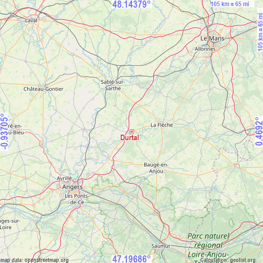
Durtal GPS coordinates[2]
47° 40' 20.892" North, 0° 14' 2.148" West
| Map corner | latitude | longitude |
|---|---|---|
| Upper-left | 48.14379°, | -0.93705° |
| Center: | 47.67247°, | -0.23393° |
| Lower-right: | 47.19686°, | 0.4692° |
| Map W x H: | 105.3×105.3 km | = 65.4×65.4mi |
| max Lat: | 51.07786° ⇑46.2% North |
| Durtal: | 47.67247° |
| min Lat: | ⇓53.8% South 41.3874° |
| min Long | Durtal | max Long |
| -5.08615° | -0.23393° | 9.52242° |
| W 19.9%⇐ | ⇒80.1% E |
Elevation
Elevation of Durtal is 38 m = 125 ft, and this is 155.7 m = 511 ft below average elevation for this country.
| Max E: |
2333 m = 7654 ft | 86.7% |
| Avg. | 193.7 m = 635 ft | |
| Durtal | 38 m = 125 ft | |
Min E: |
-1 m = -3 ft | 13.3% |
See also: France elevation on elevation.city.
Geographical zone
Durtal is located in North temperate zone (between Tropic of Cancer and the Arctic Circle). Distance of this North polar circle is 2100.5 km =1305.2 mi to North.| Distance of | km | miles | from Durtal |
|---|---|---|---|
| North Pole | 4706.4 | 2924.4 | to North |
| Arctic Circle | 2100.5 | 1305.2 | to North |
| Tropic Cancer | 2694.8 | 1674.5 | to South |
| Equator | 5300.7 | 3293.7 | to South |


Nearby cities:
15 places around Durtal: (largest is in red/bold)
• Bazouges-sur-le-Loir
5.2 km =3.2 mi,  69°
69°
• Cheviré-le-Rouge
9.5 km =5.9 mi,  155°
155°
• Clefs-Val d'Anjou
13.3 km =8.3 mi,  113°
113°
• Crosmières
10.2 km =6.3 mi,  37°
37°
• Cré-sur-Loir
5.7 km =3.5 mi,  84°
84°
• Daumeray
10 km =6.2 mi,  288°
288°
• Fougeré
8.1 km =5 mi,  127°
127°
• Jarzé
13 km =8.1 mi,  179°
179°
• Juigné
13 km =8.1 mi, 293°
• La Flèche
12.2 km =7.6 mi, 76°
• Les Rairies
3.1 km =1.9 mi,  138°
138°
• Louailles
13.4 km =8.3 mi,  354°
354°
• Lézigné
6.2 km =3.9 mi,  229°
229°
• Précigné
12.5 km =7.8 mi,  327°
327°
• Villaines-sous-Malicorne
14.3 km =8.9 mi, 44°
Sources, notices
• [Note1] Compared only with cities in France existing in our database
• [Src1] Map data: © OpenStreetMap contributors (CC-BY-SA)
• [Src2] Other city data from geonames.org with taken over terms of usage.
• [Src3] Geographical zone / Annual Mean Temperature by Robert A. Rohde @ Wikipedia
