Crémarest geodata
Crémarest (Hauts-de-France) is a populated place; located in France in Europe/Paris (GMT+2) time zone. With population of 677 people, there are 12108 cities with bigger population in this country. Compared to other cities in France, 98.8% of cities are located further ↓South; 59.5% of cities are located further →East and 88.3% of cities have higher elevation than Crémarest. Note1
Administrative division(s):
- Level 1: Hauts-de-France
- Level 2: Pas-de-Calais
- Level 3: Arrondissement de Boulogne-sur-Mer
- Level 4: Crémarest


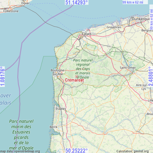
Crémarest GPS coordinates[2]
50° 41' 58.884" North, 1° 47' 5.604" East
| Map corner | latitude | longitude |
|---|---|---|
| Upper-left | 51.14293°, | 1.08176° |
| Center: | 50.69969°, | 1.78489° |
| Lower-right: | 50.25222°, | 2.48801° |
| Map W x H: | 99×99 km | = 61.5×61.5mi |
| max Lat: | 51.07786° ⇑1.2% North |
| Crémarest: | 50.69969° |
| min Lat: | ⇓98.8% South 41.3874° |
| min Long | Crémarest | max Long |
| -5.08615° | 1.78489° | 9.52242° |
| W 40.5%⇐ | ⇒59.5% E |
Elevation
Elevation of Crémarest is 34 m = 112 ft, and this is 159.7 m = 524 ft below average elevation for this country.
| Max E: |
2333 m = 7654 ft | 88.3% |
| Avg. | 193.7 m = 635 ft | |
| Crémarest | 34 m = 112 ft | |
Min E: |
-1 m = -3 ft | 11.7% |
See also: France elevation on elevation.city.
Geographical zone
Crémarest is located in North temperate zone (between Tropic of Cancer and the Arctic Circle). Distance of this North polar circle is 1763.9 km =1096 mi to North.| Distance of | km | miles | from Crémarest |
|---|---|---|---|
| North Pole | 4369.8 | 2715.3 | to North |
| Arctic Circle | 1763.9 | 1096 | to North |
| Tropic Cancer | 3031.4 | 1883.6 | to South |
| Equator | 5637.3 | 3502.9 | to South |


Nearby cities:
15 places around Crémarest: (largest is in red/bold)
• Baincthun
7.4 km =4.6 mi,  278°
278°
• Belle-et-Houllefort
5.3 km =3.3 mi,  339°
339°
• Carly
7.9 km =4.9 mi,  227°
227°
• Colembert
6.5 km =4 mi,  39°
39°
• Courset
7.2 km =4.5 mi,  145°
145°
• Desvres
4.9 km =3 mi,  134°
134°
• Hesdigneul-lès-Boulogne
9.7 km =6 mi,  243°
243°
• Isques
9.6 km =6 mi,  252°
252°
• La Capelle-lès-Boulogne
6.9 km =4.3 mi,  302°
302°
• Longfossé
5.5 km =3.4 mi,  163°
163°
• Menneville
6.2 km =3.9 mi,  112°
112°
• Quesques
10.5 km =6.5 mi,  87°
87°
• Samer
7.3 km =4.5 mi,  201°
201°
• Wierre-Effroy
9.4 km =5.8 mi, 338°
• Wirwignes
2.4 km =1.5 mi,  224°
224°
Sources, notices
• [Note1] Compared only with cities in France existing in our database
• [Src1] Map data: © OpenStreetMap contributors (CC-BY-SA)
• [Src2] Other city data from geonames.org with taken over terms of usage.
• [Src3] Geographical zone / Annual Mean Temperature by Robert A. Rohde @ Wikipedia
