Desvres geodata
Desvres (Hauts-de-France) is a populated place; located in France in Europe/Paris (GMT+2) time zone. With population of 5,109 people, there are 1928 cities with bigger population in this country. Compared to other cities in France, 98.6% of cities are located further ↓South; 59% of cities are located further →East and 61.5% of cities have higher elevation than Desvres. Note1
Administrative division(s):
- Level 1: Hauts-de-France
- Level 2: Pas-de-Calais
- Level 3: Arrondissement de Boulogne-sur-Mer
- Level 4: Desvres


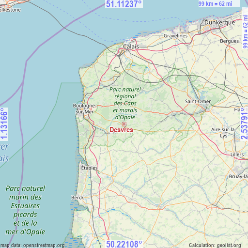
Desvres GPS coordinates[2]
50° 40' 7.824" North, 1° 50' 5.208" East
| Map corner | latitude | longitude |
|---|---|---|
| Upper-left | 51.11237°, | 1.13166° |
| Center: | 50.66884°, | 1.83478° |
| Lower-right: | 50.22108°, | 2.53791° |
| Map W x H: | 99.1×99.1 km | = 61.6×61.6mi |
| max Lat: | 51.07786° ⇑1.4% North |
| Desvres: | 50.66884° |
| min Lat: | ⇓98.6% South 41.3874° |
| min Long | Desvres | max Long |
| -5.08615° | 1.83478° | 9.52242° |
| W 41%⇐ | ⇒59% E |
Elevation
Elevation of Desvres is 98 m = 322 ft, and this is 95.7 m = 314 ft below average elevation for this country.
| Max E: |
2333 m = 7654 ft | 61.5% |
| Avg. | 193.7 m = 635 ft | |
| Desvres | 98 m = 322 ft | |
Min E: |
-1 m = -3 ft | 38.5% |
See also: France elevation on elevation.city.
Geographical zone
Desvres is located in North temperate zone (between Tropic of Cancer and the Arctic Circle). Distance of this North polar circle is 1767.3 km =1098.1 mi to North.| Distance of | km | miles | from Desvres |
|---|---|---|---|
| North Pole | 4373.2 | 2717.4 | to North |
| Arctic Circle | 1767.3 | 1098.1 | to North |
| Tropic Cancer | 3027.9 | 1881.4 | to South |
| Equator | 5633.8 | 3500.7 | to South |


Nearby cities:
15 places around Desvres: (largest is in red/bold)
• Baincthun
11.8 km =7.3 mi,  292°
292°
• Belle-et-Houllefort
10 km =6.2 mi,  327°
327°
• Bourthes
9.9 km =6.2 mi,  135°
135°
• Carly
9.5 km =5.9 mi,  258°
258°
• Colembert
8.5 km =5.3 mi,  4°
4°
• Courset
2.6 km =1.6 mi,  168°
168°
• Crémarest
4.9 km =3 mi,  314°
314°
• Hucqueliers
12.2 km =7.6 mi,  155°
155°
• La Capelle-lès-Boulogne
11.8 km =7.3 mi, 307°
• Longfossé
2.7 km =1.7 mi,  226°
226°
• Menneville
2.4 km =1.5 mi,  63°
63°
• Preures
11.1 km =6.9 mi, 163°
• Quesques
7.9 km =4.9 mi, 60°
• Samer
7.1 km =4.4 mi,  241°
241°
• Wirwignes
5.5 km =3.4 mi, 288°
Sources, notices
• [Note1] Compared only with cities in France existing in our database
• [Src1] Map data: © OpenStreetMap contributors (CC-BY-SA)
• [Src2] Other city data from geonames.org with taken over terms of usage.
• [Src3] Geographical zone / Annual Mean Temperature by Robert A. Rohde @ Wikipedia
