Samer geodata
Samer (Hauts-de-France) is a populated place; located in France in Europe/Paris (GMT+2) time zone. With population of 3,265 people, there are 2992 cities with bigger population in this country. Compared to other cities in France, 98.4% of cities are located further ↓South; 60% of cities are located further →East and 75.4% of cities have higher elevation than Samer. Note1
Administrative division(s):
- Level 1: Hauts-de-France
- Level 2: Pas-de-Calais
- Level 3: Arrondissement de Boulogne-sur-Mer
- Level 4: Samer


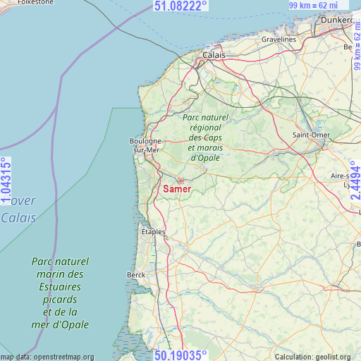
Samer GPS coordinates[2]
50° 38' 18.24" North, 1° 44' 46.608" East
| Map corner | latitude | longitude |
|---|---|---|
| Upper-left | 51.08222°, | 1.04315° |
| Center: | 50.6384°, | 1.74628° |
| Lower-right: | 50.19035°, | 2.4494° |
| Map W x H: | 99.2×99.2 km | = 61.6×61.6mi |
| max Lat: | 51.07786° ⇑1.6% North |
| Samer: | 50.6384° |
| min Lat: | ⇓98.4% South 41.3874° |
| min Long | Samer | max Long |
| -5.08615° | 1.74628° | 9.52242° |
| W 40%⇐ | ⇒60% E |
Elevation
Elevation of Samer is 66 m = 217 ft, and this is 127.7 m = 419 ft below average elevation for this country.
| Max E: |
2333 m = 7654 ft | 75.4% |
| Avg. | 193.7 m = 635 ft | |
| Samer | 66 m = 217 ft | |
Min E: |
-1 m = -3 ft | 24.6% |
See also: France elevation on elevation.city.
Geographical zone
Samer is located in North temperate zone (between Tropic of Cancer and the Arctic Circle). Distance of this North polar circle is 1770.7 km =1100.3 mi to North.| Distance of | km | miles | from Samer |
|---|---|---|---|
| North Pole | 4376.6 | 2719.5 | to North |
| Arctic Circle | 1770.7 | 1100.3 | to North |
| Tropic Cancer | 3024.5 | 1879.3 | to South |
| Equator | 5630.5 | 3498.6 | to South |


Nearby cities:
15 places around Samer: (largest is in red/bold)
• Baincthun
9.2 km =5.7 mi,  329°
329°
• Carly
3.4 km =2.1 mi,  295°
295°
• Condette
8.2 km =5.1 mi,  285°
285°
• Courset
6.8 km =4.2 mi,  82°
82°
• Crémarest
7.3 km =4.5 mi,  21°
21°
• Desvres
7.1 km =4.4 mi,  61°
61°
• Frencq
9.3 km =5.8 mi,  200°
200°
• Hesdigneul-lès-Boulogne
6.5 km =4 mi, 292°
• Isques
7.6 km =4.7 mi, 301°
• Longfossé
4.5 km =2.8 mi,  70°
70°
• Menneville
9.5 km =5.9 mi, 62°
• Nesles
6.5 km =4 mi,  257°
257°
• Neufchâtel-Hardelot
7.6 km =4.7 mi,  254°
254°
• Saint-Étienne-au-Mont
9.2 km =5.7 mi, 298°
• Wirwignes
5.2 km =3.2 mi,  11°
11°
Sources, notices
• [Note1] Compared only with cities in France existing in our database
• [Src1] Map data: © OpenStreetMap contributors (CC-BY-SA)
• [Src2] Other city data from geonames.org with taken over terms of usage.
• [Src3] Geographical zone / Annual Mean Temperature by Robert A. Rohde @ Wikipedia
