La Bazoche-Gouet geodata
La Bazoche-Gouet (Centre) is a populated place; located in France in Europe/Paris (GMT+2) time zone. With population of 1,286 people, there are 7096 cities with bigger population in this country. Compared to other cities in France, 61.9% of cities are located further ↓South; 68.9% of cities are located further →East and 64.4% of cities have lower elevation than La Bazoche-Gouet. Note1
Administrative division(s):
- Level 1: Centre
- Level 2: Département d'Eure-et-Loir
- Level 3: Arrondissement de Nogent-le-Rotrou
- Level 4: La Bazoche-Gouet


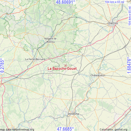
La Bazoche-Gouet GPS coordinates[2]
48° 8' 23.46" North, 0° 58' 53.868" East
| Map corner | latitude | longitude |
|---|---|---|
| Upper-left | 48.60691°, | 0.2785° |
| Center: | 48.13985°, | 0.98163° |
| Lower-right: | 47.6685°, | 1.68476° |
| Map W x H: | 104.3×104.3 km | = 64.8×64.8mi |
| max Lat: | 51.07786° ⇑38.1% North |
| La Bazoche-Gouet: | 48.13985° |
| min Lat: | ⇓61.9% South 41.3874° |
| min Long | La Bazoche-Goue | max Long |
| -5.08615° | 0.98163° | 9.52242° |
| W 31.1%⇐ | ⇒68.9% E |
Elevation
Elevation of La Bazoche-Gouet is 191 m = 627 ft, and this is 2.7 m = 9 ft below average elevation for this country.
| Max E: |
2333 m = 7654 ft | 35.6% |
| Avg. | 193.7 m = 635 ft | |
| La Bazoche-Gouet | 191 m = 627 ft | |
Min E: |
-1 m = -3 ft | 64.4% |
See also: France elevation on elevation.city.
Geographical zone
La Bazoche-Gouet is located in North temperate zone (between Tropic of Cancer and the Arctic Circle). Distance of this North polar circle is 2048.5 km =1272.9 mi to North.| Distance of | km | miles | from La Bazoche-Gouet |
|---|---|---|---|
| North Pole | 4654.4 | 2892.1 | to North |
| Arctic Circle | 2048.5 | 1272.9 | to North |
| Tropic Cancer | 2746.7 | 1706.7 | to South |
| Equator | 5352.6 | 3326 | to South |


Nearby cities:
15 places around La Bazoche-Gouet: (largest is in red/bold)
• Arrou
11.9 km =7.4 mi,  113°
113°
• Authon-du-Perche
9.1 km =5.7 mi,  313°
313°
• Beaumont-les-Autels
13.2 km =8.2 mi,  352°
352°
• Brou
16.1 km =10 mi,  57°
57°
• Choue
16 km =9.9 mi,  192°
192°
• Châtillon-en-Dunois
15.4 km =9.6 mi,  99°
99°
• Courtalain
13.5 km =8.4 mi,  118°
118°
• Droué
13.1 km =8.1 mi,  147°
147°
• Frazé
16.1 km =10 mi,  33°
33°
• Melleray
14.2 km =8.8 mi,  251°
251°
• Mondoubleau
18.8 km =11.7 mi,  199°
199°
• Souancé-au-Perche
17 km =10.6 mi,  326°
326°
• Souday
14.3 km =8.9 mi,  216°
216°
• Unverre
10.5 km =6.5 mi,  51°
51°
• Yèvres
17.2 km =10.7 mi, 62°
Sources, notices
• [Note1] Compared only with cities in France existing in our database
• [Src1] Map data: © OpenStreetMap contributors (CC-BY-SA)
• [Src2] Other city data from geonames.org with taken over terms of usage.
• [Src3] Geographical zone / Annual Mean Temperature by Robert A. Rohde @ Wikipedia
