Fontaine-Bellenger geodata
Fontaine-Bellenger (Normandy) is a populated place; located in France in Europe/Paris (GMT+2) time zone. With population of 853 people, there are 10054 cities with bigger population in this country. Compared to other cities in France, 84% of cities are located further ↓South; 66% of cities are located further →East and 53.6% of cities have lower elevation than Fontaine-Bellenger. Note1
Administrative division(s):
- Level 1: Normandy
- Level 2: Département de l'Eure
- Level 3: Les Andelys
- Level 4: Fontaine-Bellenger


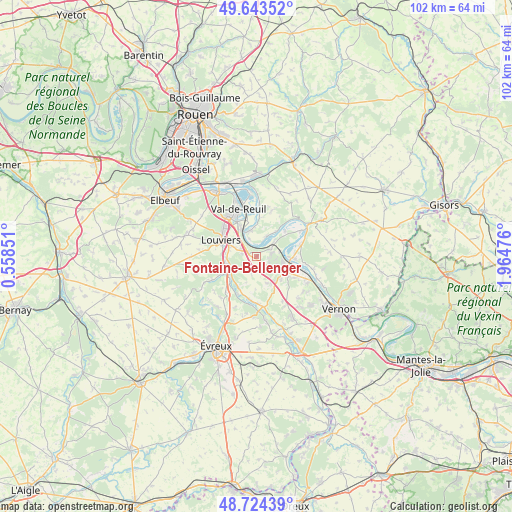
Fontaine-Bellenger GPS coordinates[2]
49° 11' 9.924" North, 1° 15' 41.904" East
| Map corner | latitude | longitude |
|---|---|---|
| Upper-left | 49.64352°, | 0.55851° |
| Center: | 49.18609°, | 1.26164° |
| Lower-right: | 48.72439°, | 1.96476° |
| Map W x H: | 102.2×102.2 km | = 63.5×63.5mi |
| max Lat: | 51.07786° ⇑16% North |
| Fontaine-Bellenger: | 49.18609° |
| min Lat: | ⇓84% South 41.3874° |
| min Long | Fontaine-Bellen | max Long |
| -5.08615° | 1.26164° | 9.52242° |
| W 34%⇐ | ⇒66% E |
Elevation
Elevation of Fontaine-Bellenger is 145 m = 476 ft, and this is 48.7 m = 160 ft below average elevation for this country.
| Max E: |
2333 m = 7654 ft | 46.4% |
| Avg. | 193.7 m = 635 ft | |
| Fontaine-Bellenger | 145 m = 476 ft | |
Min E: |
-1 m = -3 ft | 53.6% |
See also: France elevation on elevation.city.
Geographical zone
Fontaine-Bellenger is located in North temperate zone (between Tropic of Cancer and the Arctic Circle). Distance of this North polar circle is 1932.2 km =1200.6 mi to North.| Distance of | km | miles | from Fontaine-Bellenger |
|---|---|---|---|
| North Pole | 4538.1 | 2819.8 | to North |
| Arctic Circle | 1932.2 | 1200.6 | to North |
| Tropic Cancer | 2863.1 | 1779 | to South |
| Equator | 5469 | 3398.3 | to South |


Nearby cities:
15 places around Fontaine-Bellenger: (largest is in red/bold)
• Acquigny
6.3 km =3.9 mi,  257°
257°
• Andé
5.3 km =3.3 mi,  343°
343°
• Aubevoye
5.6 km =3.5 mi,  107°
107°
• Courcelles-sur-Seine
7.2 km =4.5 mi,  92°
92°
• Fontaine-Heudebourg
7.1 km =4.4 mi,  209°
209°
• Gaillon
6.4 km =4 mi,  116°
116°
• Heudebouville
1.8 km =1.1 mi,  301°
301°
• Heudreville-sur-Eure
7.3 km =4.5 mi,  226°
226°
• Muids
4.6 km =2.9 mi,  26°
26°
• Pinterville
6.3 km =3.9 mi,  275°
275°
• Saint-Aubin-sur-Gaillon
6.6 km =4.1 mi,  131°
131°
• Saint-Pierre-du-Vauvray
5.9 km =3.7 mi,  330°
330°
• Saint-Étienne-du-Vauvray
6.9 km =4.3 mi, 333°
• Venables
2.8 km =1.7 mi,  59°
59°
• Villers-sur-le-Roule
4.8 km =3 mi,  76°
76°
Sources, notices
• [Note1] Compared only with cities in France existing in our database
• [Src1] Map data: © OpenStreetMap contributors (CC-BY-SA)
• [Src2] Other city data from geonames.org with taken over terms of usage.
• [Src3] Geographical zone / Annual Mean Temperature by Robert A. Rohde @ Wikipedia
