Muids geodata
Muids (Normandy) is a populated place; located in France in Europe/Paris (GMT+2) time zone. With population of 887 people, there are 9762 cities with bigger population in this country. Compared to other cities in France, 84.7% of cities are located further ↓South; 65.7% of cities are located further →East and 95% of cities have higher elevation than Muids. Note1
Administrative division(s):
- Level 1: Normandy
- Level 2: Département de l'Eure
- Level 3: Les Andelys
- Level 4: Muids


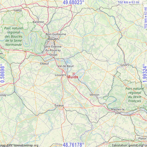
Muids GPS coordinates[2]
49° 13' 23.304" North, 1° 17' 24.396" East
| Map corner | latitude | longitude |
|---|---|---|
| Upper-left | 49.68023°, | 0.58698° |
| Center: | 49.22314°, | 1.29011° |
| Lower-right: | 48.76178°, | 1.99324° |
| Map W x H: | 102.1×102.1 km | = 63.4×63.4mi |
| max Lat: | 51.07786° ⇑15.3% North |
| Muids: | 49.22314° |
| min Lat: | ⇓84.7% South 41.3874° |
| min Long | Muids | max Long |
| -5.08615° | 1.29011° | 9.52242° |
| W 34.3%⇐ | ⇒65.7% E |
Elevation
Elevation of Muids is 17 m = 56 ft, and this is 176.7 m = 580 ft below average elevation for this country.
| Max E: |
2333 m = 7654 ft | 95% |
| Avg. | 193.7 m = 635 ft | |
| Muids | 17 m = 56 ft | |
Min E: |
-1 m = -3 ft | 5% |
See also: France elevation on elevation.city.
Geographical zone
Muids is located in North temperate zone (between Tropic of Cancer and the Arctic Circle). Distance of this North polar circle is 1928.1 km =1198.1 mi to North.| Distance of | km | miles | from Muids |
|---|---|---|---|
| North Pole | 4534 | 2817.3 | to North |
| Arctic Circle | 1928.1 | 1198.1 | to North |
| Tropic Cancer | 2867.2 | 1781.6 | to South |
| Equator | 5473.1 | 3400.8 | to South |


Nearby cities:
15 places around Muids: (largest is in red/bold)
• Andé
3.7 km =2.3 mi,  284°
284°
• Aubevoye
6.7 km =4.2 mi,  150°
150°
• Bouafles
7.2 km =4.5 mi,  98°
98°
• Courcelles-sur-Seine
6.8 km =4.2 mi,  131°
131°
• Fontaine-Bellenger
4.6 km =2.9 mi,  206°
206°
• Gaillon
7.8 km =4.8 mi, 152°
• Heudebouville
4.8 km =3 mi,  228°
228°
• Le Vaudreuil
6.8 km =4.2 mi,  300°
300°
• Saint-Aubin-sur-Gaillon
8.9 km =5.5 mi,  161°
161°
• Saint-Pierre-du-Vauvray
5.1 km =3.2 mi, 281°
• Saint-Étienne-du-Vauvray
5.6 km =3.5 mi,  291°
291°
• Tosny
6.1 km =3.8 mi,  94°
94°
• Val-de-Reuil
8.1 km =5 mi,  314°
314°
• Venables
2.7 km =1.7 mi,  172°
172°
• Villers-sur-le-Roule
4 km =2.5 mi,  138°
138°
Sources, notices
• [Note1] Compared only with cities in France existing in our database
• [Src1] Map data: © OpenStreetMap contributors (CC-BY-SA)
• [Src2] Other city data from geonames.org with taken over terms of usage.
• [Src3] Geographical zone / Annual Mean Temperature by Robert A. Rohde @ Wikipedia
