Coufouleux geodata
Coufouleux (Occitanie) is a populated place; located in France in Europe/Paris (GMT+2) time zone. With population of 2,135 people, there are 4500 cities with bigger population in this country. Compared to other cities in France, 89% of cities are located further ↑North; 60.1% of cities are located further →East and 54.4% of cities have higher elevation than Coufouleux. Note1


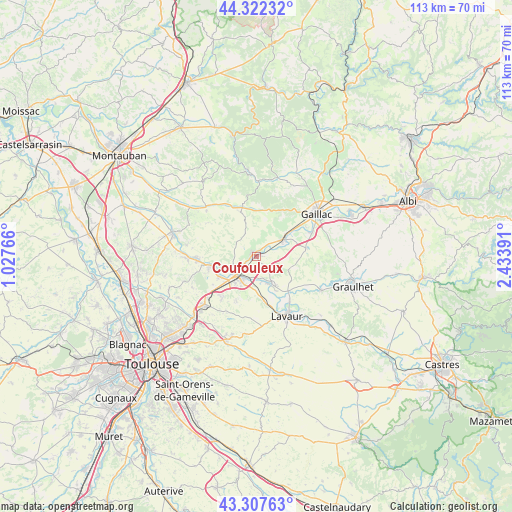
Coufouleux GPS coordinates[2]
43° 49' 1.668" North, 1° 43' 50.808" East
| Map corner | latitude | longitude |
|---|---|---|
| Upper-left | 44.32232°, | 1.02766° |
| Center: | 43.81713°, | 1.73078° |
| Lower-right: | 43.30763°, | 2.43391° |
| Map W x H: | 112.8×112.8 km | = 70.1×70.1mi |
| max Lat: | 51.07786° ⇑89% North |
| Coufouleux: | 43.81713° |
| min Lat: | ⇓11% South 41.3874° |
| min Long | Coufouleux | max Long |
| -5.08615° | 1.73078° | 9.52242° |
| W 39.9%⇐ | ⇒60.1% E |
Elevation
Elevation of Coufouleux is 118 m = 387 ft, and this is 75.7 m = 248 ft below average elevation for this country.
| Max E: |
2333 m = 7654 ft | 54.4% |
| Avg. | 193.7 m = 635 ft | |
| Coufouleux | 118 m = 387 ft | |
Min E: |
-1 m = -3 ft | 45.6% |
See also: France elevation on elevation.city.
Geographical zone
Coufouleux is located in North temperate zone (between Tropic of Cancer and the Arctic Circle). Distance of this Northern Tropic circle is 2266.1 km =1408.1 mi to South.| Distance of | km | miles | from Coufouleux |
|---|---|---|---|
| North Pole | 5135.1 | 3190.8 | to North |
| Arctic Circle | 2529.2 | 1571.6 | to North |
| Tropic Cancer | 2266.1 | 1408.1 | to South |
| Equator | 4872 | 3027.3 | to South |


Nearby cities:
15 places around Coufouleux: (largest is in red/bold)
• Ambres
11.5 km =7.1 mi,  145°
145°
• Bessières
10.2 km =6.3 mi,  258°
258°
• Buzet-sur-Tarn
8.9 km =5.5 mi,  242°
242°
• Giroussens
7.1 km =4.4 mi, 149°
• La Magdelaine-sur-Tarn
15 km =9.3 mi,  267°
267°
• Lavaur
15 km =9.3 mi, 151°
• Lisle-sur-Tarn
7.5 km =4.7 mi,  58°
58°
• Mirepoix-sur-Tarn
12.8 km =8 mi, 268°
• Montans
13.6 km =8.5 mi,  65°
65°
• Parisot
8.1 km =5 mi,  103°
103°
• Rabastens
1 km =0.6 mi,  327°
327°
• Roquesérière
11.8 km =7.3 mi,  219°
219°
• Saint-Lieux-lès-Lavaur
6.4 km =4 mi,  160°
160°
• Saint-Sulpice-la-Pointe
5.9 km =3.7 mi, 218°
• Salvagnac
10.4 km =6.5 mi,  341°
341°
Sources, notices
• [Note1] Compared only with cities in France existing in our database
• [Src1] Map data: © OpenStreetMap contributors (CC-BY-SA)
• [Src2] Other city data from geonames.org with taken over terms of usage.
• [Src3] Geographical zone / Annual Mean Temperature by Robert A. Rohde @ Wikipedia
