Giroussens geodata
Giroussens (Occitanie) is a populated place; located in France in Europe/Paris (GMT+2) time zone. With population of 1,089 people, there are 8201 cities with bigger population in this country. Compared to other cities in France, 89.6% of cities are located further ↑North; 59.6% of cities are located further →East and 62.5% of cities have lower elevation than Giroussens. Note1
Administrative division(s):
- Level 1: Occitanie
- Level 2: Tarn
- Level 3: Arrondissement de Castres
- Level 4: Giroussens


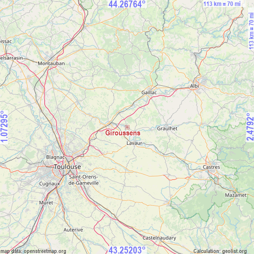
Giroussens GPS coordinates[2]
43° 45' 43.164" North, 1° 46' 33.888" East
| Map corner | latitude | longitude |
|---|---|---|
| Upper-left | 44.26764°, | 1.07295° |
| Center: | 43.76199°, | 1.77608° |
| Lower-right: | 43.25203°, | 2.4792° |
| Map W x H: | 112.9×112.9 km | = 70.2×70.2mi |
| max Lat: | 51.07786° ⇑89.6% North |
| Giroussens: | 43.76199° |
| min Lat: | ⇓10.4% South 41.3874° |
| min Long | Giroussens | max Long |
| -5.08615° | 1.77608° | 9.52242° |
| W 40.4%⇐ | ⇒59.6% E |
Elevation
Elevation of Giroussens is 182 m = 597 ft, and this is 11.7 m = 38 ft below average elevation for this country.
| Max E: |
2333 m = 7654 ft | 37.5% |
| Avg. | 193.7 m = 635 ft | |
| Giroussens | 182 m = 597 ft | |
Min E: |
-1 m = -3 ft | 62.5% |
See also: France elevation on elevation.city.
Geographical zone
Giroussens is located in North temperate zone (between Tropic of Cancer and the Arctic Circle). Distance of this Northern Tropic circle is 2260 km =1404.3 mi to South.| Distance of | km | miles | from Giroussens |
|---|---|---|---|
| North Pole | 5141.2 | 3194.6 | to North |
| Arctic Circle | 2535.3 | 1575.4 | to North |
| Tropic Cancer | 2260 | 1404.3 | to South |
| Equator | 4865.9 | 3023.5 | to South |


Nearby cities:
15 places around Giroussens: (largest is in red/bold)
• Ambres
4.5 km =2.8 mi,  138°
138°
• Bessières
14.2 km =8.8 mi,  286°
286°
• Briatexte
10.7 km =6.6 mi,  95°
95°
• Buzet-sur-Tarn
11.7 km =7.3 mi,  279°
279°
• Coufouleux
7.1 km =4.4 mi,  329°
329°
• Fiac
12.5 km =7.8 mi,  122°
122°
• Labastide-Saint-Georges
8.9 km =5.5 mi, 141°
• Lavaur
7.8 km =4.8 mi,  154°
154°
• Lisle-sur-Tarn
10.4 km =6.5 mi,  15°
15°
• Parisot
6 km =3.7 mi,  45°
45°
• Rabastens
8.2 km =5.1 mi, 329°
• Roquesérière
11.5 km =7.1 mi,  254°
254°
• Saint-Gauzens
10 km =6.2 mi, 99°
• Saint-Lieux-lès-Lavaur
1.5 km =0.9 mi,  272°
272°
• Saint-Sulpice-la-Pointe
7.4 km =4.6 mi, 281°
Sources, notices
• [Note1] Compared only with cities in France existing in our database
• [Src1] Map data: © OpenStreetMap contributors (CC-BY-SA)
• [Src2] Other city data from geonames.org with taken over terms of usage.
• [Src3] Geographical zone / Annual Mean Temperature by Robert A. Rohde @ Wikipedia
