Lisle-sur-Tarn geodata
Lisle-sur-Tarn (Occitanie) is a populated place; located in France in Europe/Paris (GMT+2) time zone. With population of 3,871 people, there are 2540 cities with bigger population in this country. Compared to other cities in France, 88.6% of cities are located further ↑North; 59.3% of cities are located further →East and 50.1% of cities have lower elevation than Lisle-sur-Tarn. Note1


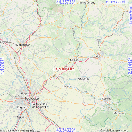
Lisle-sur-Tarn GPS coordinates[2]
43° 51' 8.964" North, 1° 48' 39.564" East
| Map corner | latitude | longitude |
|---|---|---|
| Upper-left | 44.35738°, | 1.10787° |
| Center: | 43.85249°, | 1.81099° |
| Lower-right: | 43.34329°, | 2.51412° |
| Map W x H: | 112.8×112.8 km | = 70.1×70.1mi |
| max Lat: | 51.07786° ⇑88.6% North |
| Lisle-sur-Tarn: | 43.85249° |
| min Lat: | ⇓11.4% South 41.3874° |
| min Long | Lisle-sur-Tarn | max Long |
| -5.08615° | 1.81099° | 9.52242° |
| W 40.7%⇐ | ⇒59.3% E |
Elevation
Elevation of Lisle-sur-Tarn is 132 m = 433 ft, and this is 61.7 m = 202 ft below average elevation for this country.
| Max E: |
2333 m = 7654 ft | 49.9% |
| Avg. | 193.7 m = 635 ft | |
| Lisle-sur-Tarn | 132 m = 433 ft | |
Min E: |
-1 m = -3 ft | 50.1% |
See also: France elevation on elevation.city.
Geographical zone
Lisle-sur-Tarn is located in North temperate zone (between Tropic of Cancer and the Arctic Circle). Distance of this Northern Tropic circle is 2270 km =1410.5 mi to South.| Distance of | km | miles | from Lisle-sur-Tarn |
|---|---|---|---|
| North Pole | 5131.1 | 3188.3 | to North |
| Arctic Circle | 2525.2 | 1569.1 | to North |
| Tropic Cancer | 2270 | 1410.5 | to South |
| Equator | 4875.9 | 3029.7 | to South |


Nearby cities:
15 places around Lisle-sur-Tarn: (largest is in red/bold)
• Ambres
13.4 km =8.3 mi,  179°
179°
• Brens
8.6 km =5.3 mi,  63°
63°
• Briatexte
13.6 km =8.5 mi,  144°
144°
• Cadalen
13.6 km =8.5 mi,  91°
91°
• Castelnau-de-Montmiral
12.6 km =7.8 mi,  3°
3°
• Coufouleux
7.5 km =4.7 mi,  238°
238°
• Gaillac
8.8 km =5.5 mi,  51°
51°
• Giroussens
10.4 km =6.5 mi,  195°
195°
• Montans
6.2 km =3.9 mi,  74°
74°
• Parisot
6 km =3.7 mi,  166°
166°
• Rabastens
7.6 km =4.7 mi,  246°
246°
• Saint-Lieux-lès-Lavaur
10.9 km =6.8 mi, 203°
• Saint-Sulpice-la-Pointe
13.3 km =8.3 mi,  229°
229°
• Salvagnac
11.5 km =7.1 mi,  301°
301°
• Técou
11.2 km =7 mi,  95°
95°
Sources, notices
• [Note1] Compared only with cities in France existing in our database
• [Src1] Map data: © OpenStreetMap contributors (CC-BY-SA)
• [Src2] Other city data from geonames.org with taken over terms of usage.
• [Src3] Geographical zone / Annual Mean Temperature by Robert A. Rohde @ Wikipedia
