Saint-Sulpice-la-Pointe geodata
Saint-Sulpice-la-Pointe (Occitanie) is a populated place; located in France in Europe/Paris (GMT+2) time zone. With population of 6,714 people, there are 1477 cities with bigger population in this country. Compared to other cities in France, 89.4% of cities are located further ↑North; 60.6% of cities are located further →East and 55.6% of cities have higher elevation than Saint-Sulpice-la-Pointe. Note1
Administrative division(s):
- Level 1: Occitanie
- Level 2: Tarn
- Level 3: Arrondissement de Castres
- Level 4: Saint-Sulpice-la-Pointe
Current local time in Saint-Sulpice-la-Pointe:
06:03 AM, WednesdayDifference from your time zone: hours


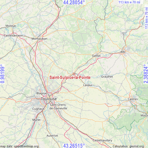
Saint-Sulpice-la-Pointe GPS coordinates[2]
43° 46' 30" North, 1° 41' 6.396" East
| Map corner | latitude | longitude |
|---|---|---|
| Upper-left | 44.28054°, | 0.98199° |
| Center: | 43.775°, | 1.68511° |
| Lower-right: | 43.26515°, | 2.38824° |
| Map W x H: | 112.9×112.9 km | = 70.2×70.2mi |
| max Lat: | 51.07786° ⇑89.4% North |
| Saint-Sulpice-la-Pointe: | 43.775° |
| min Lat: | ⇓10.6% South 41.3874° |
| min Long | Saint-Sulpice-l | max Long |
| -5.08615° | 1.68511° | 9.52242° |
| W 39.4%⇐ | ⇒60.6% E |
Elevation
Elevation of Saint-Sulpice-la-Pointe is 115 m = 377 ft, and this is 78.7 m = 258 ft below average elevation for this country.
| Max E: |
2333 m = 7654 ft | 55.6% |
| Avg. | 193.7 m = 635 ft | |
| Saint-Sulpice-la-Pointe | 115 m = 377 ft | |
Min E: |
-1 m = -3 ft | 44.4% |
See also: France elevation on elevation.city.
Geographical zone
Saint-Sulpice-la-Pointe is located in North temperate zone (between Tropic of Cancer and the Arctic Circle). Distance of this Northern Tropic circle is 2261.4 km =1405.2 mi to South.| Distance of | km | miles | from Saint-Sulpice-la-Pointe |
|---|---|---|---|
| North Pole | 5139.7 | 3193.7 | to North |
| Arctic Circle | 2533.9 | 1574.5 | to North |
| Tropic Cancer | 2261.4 | 1405.2 | to South |
| Equator | 4867.3 | 3024.4 | to South |


Nearby cities:
15 places around Saint-Sulpice-la-Pointe: (largest is in red/bold)
• Ambres
11.3 km =7 mi,  115°
115°
• Bessières
6.9 km =4.3 mi,  292°
292°
• Buzet-sur-Tarn
4.2 km =2.6 mi,  277°
277°
• Coufouleux
5.9 km =3.7 mi,  38°
38°
• Garidech
12.3 km =7.6 mi,  234°
234°
• Giroussens
7.4 km =4.6 mi,  101°
101°
• La Magdelaine-sur-Tarn
12 km =7.5 mi, 289°
• Mirepoix-sur-Tarn
10.2 km =6.3 mi,  295°
295°
• Montastruc-la-Conseillère
9.8 km =6.1 mi, 231°
• Montjoire
12.2 km =7.6 mi,  266°
266°
• Parisot
11.9 km =7.4 mi,  76°
76°
• Paulhac
10.5 km =6.5 mi,  258°
258°
• Rabastens
6.4 km =4 mi,  29°
29°
• Roquesérière
5.9 km =3.7 mi,  220°
220°
• Saint-Lieux-lès-Lavaur
5.9 km =3.7 mi, 103°
Sources, notices
• [Note1] Compared only with cities in France existing in our database
• [Src1] Map data: © OpenStreetMap contributors (CC-BY-SA)
• [Src2] Other city data from geonames.org with taken over terms of usage.
• [Src3] Geographical zone / Annual Mean Temperature by Robert A. Rohde @ Wikipedia
