Cosswiller geodata
Cosswiller (Grand Est) is a populated place; located in France in Europe/Paris (GMT+2) time zone. With population of 549 people, there are 14229 cities with bigger population in this country. Compared to other cities in France, 71.6% of cities are located further ↓South; 97.3% of cities are located further ←West and 75.3% of cities have lower elevation than Cosswiller. Note1
Administrative division(s):
- Level 1: Grand Est
- Level 2: Bas-Rhin
- Level 3: Arrondissement de Molsheim
- Level 4: Cosswiller


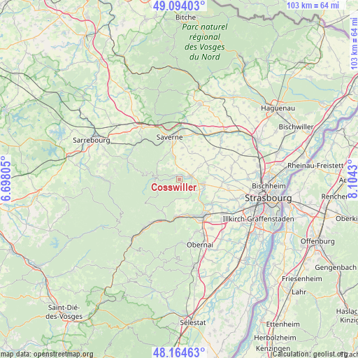
Cosswiller GPS coordinates[2]
48° 37' 53.292" North, 7° 24' 4.212" East
| Map corner | latitude | longitude |
|---|---|---|
| Upper-left | 49.09403°, | 6.69805° |
| Center: | 48.63147°, | 7.40117° |
| Lower-right: | 48.16463°, | 8.1043° |
| Map W x H: | 103.3×103.3 km | = 64.2×64.2mi |
| max Lat: | 51.07786° ⇑28.4% North |
| Cosswiller: | 48.63147° |
| min Lat: | ⇓71.6% South 41.3874° |
| min Long | Cosswiller | max Long |
| -5.08615° | 7.40117° | 9.52242° |
| W 97.3%⇐ | ⇒2.7% E |
Elevation
Elevation of Cosswiller is 251 m = 823 ft, and this is 57.3 m = 188 ft above average elevation for this country.
| Max E: |
2333 m = 7654 ft | 24.7% |
| Cosswiller | 251 m 823 ft | |
| Avg. | 193.7 m = 635 ft | |
Min E: |
-1 m = -3 ft | 75.3% |
See also: France elevation on elevation.city.
Geographical zone
Cosswiller is located in North temperate zone (between Tropic of Cancer and the Arctic Circle). Distance of this North polar circle is 1993.9 km =1239 mi to North.| Distance of | km | miles | from Cosswiller |
|---|---|---|---|
| North Pole | 4599.7 | 2858.1 | to North |
| Arctic Circle | 1993.9 | 1239 | to North |
| Tropic Cancer | 2801.4 | 1740.7 | to South |
| Equator | 5407.3 | 3359.9 | to South |


Nearby cities:
15 places around Cosswiller: (largest is in red/bold)
• Bergbieten
7.4 km =4.6 mi,  146°
146°
• Dangolsheim
8.2 km =5.1 mi,  144°
144°
• Hohengœft
6.3 km =3.9 mi,  58°
58°
• Irmstett
7.5 km =4.7 mi,  130°
130°
• Kirchheim
7.4 km =4.6 mi,  109°
109°
• Marlenheim
6.7 km =4.2 mi,  99°
99°
• Marmoutier
6.7 km =4.2 mi,  347°
347°
• Nordheim
7.9 km =4.9 mi,  86°
86°
• Romanswiller
1.6 km =1 mi,  16°
16°
• Thal-Marmoutier
8.6 km =5.3 mi,  335°
335°
• Traenheim
6.2 km =3.9 mi, 130°
• Wangen
5 km =3.1 mi, 106°
• Wangenbourg-Engenthal
7.1 km =4.4 mi,  266°
266°
• Wasselonne
3.3 km =2.1 mi,  77°
77°
• Westhoffen
4.4 km =2.7 mi, 135°
Sources, notices
• [Note1] Compared only with cities in France existing in our database
• [Src1] Map data: © OpenStreetMap contributors (CC-BY-SA)
• [Src2] Other city data from geonames.org with taken over terms of usage.
• [Src3] Geographical zone / Annual Mean Temperature by Robert A. Rohde @ Wikipedia
