Cornimont geodata
Cornimont (Grand Est) is a populated place; located in France in Europe/Paris (GMT+2) time zone. With population of 3,966 people, there are 2482 cities with bigger population in this country. Compared to other cities in France, 58.6% of cities are located further ↓South; 93.8% of cities are located further ←West and 93% of cities have lower elevation than Cornimont. Note1
Administrative division(s):
- Level 1: Grand Est
- Level 2: Vosges
- Level 3: Arrondissement d’Épinal
- Level 4: Cornimont


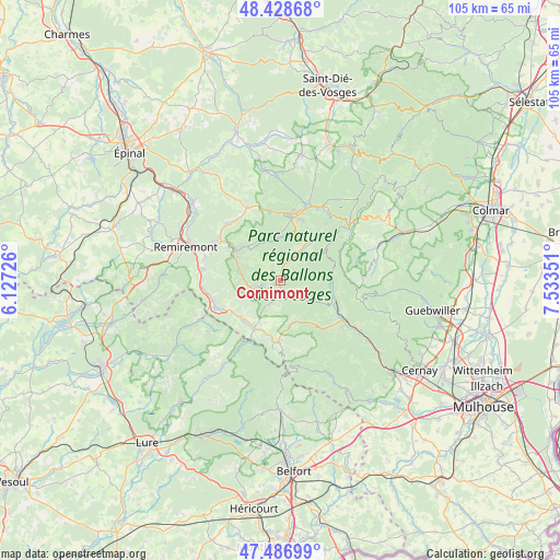
Cornimont GPS coordinates[2]
47° 57' 35.928" North, 6° 49' 49.368" East
| Map corner | latitude | longitude |
|---|---|---|
| Upper-left | 48.42868°, | 6.12726° |
| Center: | 47.95998°, | 6.83038° |
| Lower-right: | 47.48699°, | 7.53351° |
| Map W x H: | 104.7×104.7 km | = 65.1×65.1mi |
| max Lat: | 51.07786° ⇑41.4% North |
| Cornimont: | 47.95998° |
| min Lat: | ⇓58.6% South 41.3874° |
| min Long | Cornimont | max Long |
| -5.08615° | 6.83038° | 9.52242° |
| W 93.8%⇐ | ⇒6.2% E |
Elevation
Elevation of Cornimont is 505 m = 1657 ft, and this is 311.3 m = 1021 ft above average elevation for this country.
| Max E: |
2333 m = 7654 ft | 7% |
| Cornimont | 505 m 1657 ft | |
| Avg. | 193.7 m = 635 ft | |
Min E: |
-1 m = -3 ft | 93% |
See also: France elevation on elevation.city.
Geographical zone
Cornimont is located in North temperate zone (between Tropic of Cancer and the Arctic Circle). Distance of this North polar circle is 2068.5 km =1285.3 mi to North.| Distance of | km | miles | from Cornimont |
|---|---|---|---|
| North Pole | 4674.4 | 2904.5 | to North |
| Arctic Circle | 2068.5 | 1285.3 | to North |
| Tropic Cancer | 2726.7 | 1694.3 | to South |
| Equator | 5332.6 | 3313.5 | to South |


Nearby cities:
15 places around Cornimont: (largest is in red/bold)
• Basse-sur-le-Rupt
6.2 km =3.9 mi,  297°
297°
• Bussang
8.6 km =5.3 mi,  168°
168°
• Ferdrupt
10.8 km =6.7 mi,  236°
236°
• Fresse-sur-Moselle
9.9 km =6.2 mi,  199°
199°
• Kruth
10.5 km =6.5 mi,  107°
107°
• La Bresse
5.1 km =3.2 mi,  30°
30°
• Le Ménil
7.1 km =4.4 mi,  210°
210°
• Le Thillot
10.3 km =6.4 mi, 209°
• Ramonchamp
9.8 km =6.1 mi,  222°
222°
• Rochesson
7.6 km =4.7 mi,  334°
334°
• Sapois
8.8 km =5.5 mi,  318°
318°
• Saulxures-sur-Moselotte
4.6 km =2.9 mi,  254°
254°
• Thiéfosse
7.5 km =4.7 mi,  278°
278°
• Vagney
9.9 km =6.2 mi, 301°
• Ventron
3.8 km =2.4 mi,  126°
126°
Sources, notices
• [Note1] Compared only with cities in France existing in our database
• [Src1] Map data: © OpenStreetMap contributors (CC-BY-SA)
• [Src2] Other city data from geonames.org with taken over terms of usage.
• [Src3] Geographical zone / Annual Mean Temperature by Robert A. Rohde @ Wikipedia
