Ventron geodata
Ventron (Grand Est) is a populated place; located in France in Europe/Paris (GMT+2) time zone. With population of 922 people, there are 9460 cities with bigger population in this country. Compared to other cities in France, 58.2% of cities are located further ↓South; 94.1% of cities are located further ←West and 95.7% of cities have lower elevation than Ventron. Note1
Administrative division(s):
- Level 1: Grand Est
- Level 2: Vosges
- Level 3: Arrondissement d’Épinal
- Level 4: Ventron


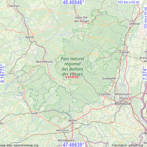
Ventron GPS coordinates[2]
47° 56' 22.452" North, 6° 52' 15.132" East
| Map corner | latitude | longitude |
|---|---|---|
| Upper-left | 48.40846°, | 6.16775° |
| Center: | 47.93957°, | 6.87087° |
| Lower-right: | 47.46639°, | 7.574° |
| Map W x H: | 104.7×104.7 km | = 65.1×65.1mi |
| max Lat: | 51.07786° ⇑41.8% North |
| Ventron: | 47.93957° |
| min Lat: | ⇓58.2% South 41.3874° |
| min Long | Ventron | max Long |
| -5.08615° | 6.87087° | 9.52242° |
| W 94.1%⇐ | ⇒5.9% E |
Elevation
Elevation of Ventron is 626 m = 2054 ft, and this is 432.3 m = 1418 ft above average elevation for this country.
| Max E: |
2333 m = 7654 ft | 4.3% |
| Ventron | 626 m 2054 ft | |
| Avg. | 193.7 m = 635 ft | |
Min E: |
-1 m = -3 ft | 95.7% |
See also: France elevation on elevation.city.
Geographical zone
Ventron is located in North temperate zone (between Tropic of Cancer and the Arctic Circle). Distance of this North polar circle is 2070.8 km =1286.7 mi to North.| Distance of | km | miles | from Ventron |
|---|---|---|---|
| North Pole | 4676.7 | 2906 | to North |
| Arctic Circle | 2070.8 | 1286.7 | to North |
| Tropic Cancer | 2724.5 | 1692.9 | to South |
| Equator | 5330.4 | 3312.2 | to South |


Nearby cities:
15 places around Ventron: (largest is in red/bold)
• Basse-sur-le-Rupt
9.9 km =6.2 mi,  301°
301°
• Bussang
6.3 km =3.9 mi,  192°
192°
• Cornimont
3.8 km =2.4 mi,  306°
306°
• Fellering
9.8 km =6.1 mi,  119°
119°
• Fresse-sur-Moselle
9.5 km =5.9 mi,  221°
221°
• Husseren-Wesserling
10.8 km =6.7 mi,  125°
125°
• Kruth
7.1 km =4.4 mi,  97°
97°
• La Bresse
6.7 km =4.2 mi,  356°
356°
• Le Ménil
7.7 km =4.8 mi,  239°
239°
• Le Thillot
10.5 km =6.5 mi,  230°
230°
• Oderen
8.4 km =5.2 mi,  112°
112°
• Ramonchamp
10.9 km =6.8 mi, 242°
• Saint-Maurice-sur-Moselle
9.6 km =6 mi,  200°
200°
• Saulxures-sur-Moselotte
7.6 km =4.7 mi,  277°
277°
• Thiéfosse
11 km =6.8 mi,  288°
288°
Sources, notices
• [Note1] Compared only with cities in France existing in our database
• [Src1] Map data: © OpenStreetMap contributors (CC-BY-SA)
• [Src2] Other city data from geonames.org with taken over terms of usage.
• [Src3] Geographical zone / Annual Mean Temperature by Robert A. Rohde @ Wikipedia
