Ceton geodata
Ceton (Normandy) is a populated place; located in France in Europe/Paris (GMT+2) time zone. With population of 1,955 people, there are 4896 cities with bigger population in this country. Compared to other cities in France, 63.2% of cities are located further ↓South; 71% of cities are located further →East and 53.8% of cities have higher elevation than Ceton. Note1
Administrative division(s):
- Level 1: Normandy
- Level 2: Département de l'Orne
- Level 3: Arrondissement de Mortagne-au-Perche
- Level 4: Ceton


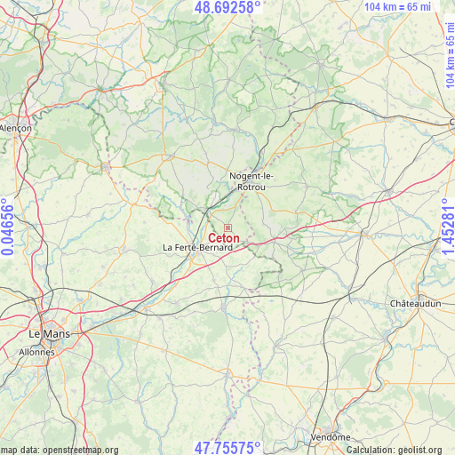
Ceton GPS coordinates[2]
48° 13' 34.716" North, 0° 44' 58.848" East
| Map corner | latitude | longitude |
|---|---|---|
| Upper-left | 48.69258°, | 0.04656° |
| Center: | 48.22631°, | 0.74968° |
| Lower-right: | 47.75575°, | 1.45281° |
| Map W x H: | 104.2×104.2 km | = 64.7×64.7mi |
| max Lat: | 51.07786° ⇑36.8% North |
| Ceton: | 48.22631° |
| min Lat: | ⇓63.2% South 41.3874° |
| min Long | Ceton | max Long |
| -5.08615° | 0.74968° | 9.52242° |
| W 29%⇐ | ⇒71% E |
Elevation
Elevation of Ceton is 120 m = 394 ft, and this is 73.7 m = 242 ft below average elevation for this country.
| Max E: |
2333 m = 7654 ft | 53.8% |
| Avg. | 193.7 m = 635 ft | |
| Ceton | 120 m = 394 ft | |
Min E: |
-1 m = -3 ft | 46.2% |
See also: France elevation on elevation.city.
Geographical zone
Ceton is located in North temperate zone (between Tropic of Cancer and the Arctic Circle). Distance of this North polar circle is 2038.9 km =1266.9 mi to North.| Distance of | km | miles | from Ceton |
|---|---|---|---|
| North Pole | 4644.8 | 2886.1 | to North |
| Arctic Circle | 2038.9 | 1266.9 | to North |
| Tropic Cancer | 2756.3 | 1712.7 | to South |
| Equator | 5362.3 | 3332 | to South |


Nearby cities:
15 places around Ceton: (largest is in red/bold)
• Authon-du-Perche
11.1 km =6.9 mi,  107°
107°
• Avezé
5.3 km =3.3 mi,  270°
270°
• Cherreau
6.1 km =3.8 mi,  232°
232°
• Cherré
9 km =5.6 mi, 228°
• Cormes
7.2 km =4.5 mi,  207°
207°
• La Chapelle-du-Bois
11.6 km =7.2 mi, 267°
• La Ferté-Bernard
8.4 km =5.2 mi,  238°
238°
• La Rouge
7.4 km =4.6 mi,  336°
336°
• Mâle
5.1 km =3.2 mi,  350°
350°
• Nogent-le-Rotrou
11.9 km =7.4 mi,  26°
26°
• Préaux-du-Perche
12.1 km =7.5 mi, 348°
• Préval
9.3 km =5.8 mi,  276°
276°
• Saint-Germain-de-la-Coudre
12.3 km =7.6 mi,  299°
299°
• Saint-Hilaire-sur-Erre
9.6 km =6 mi,  355°
355°
• Souancé-au-Perche
9 km =5.6 mi,  59°
59°
Sources, notices
• [Note1] Compared only with cities in France existing in our database
• [Src1] Map data: © OpenStreetMap contributors (CC-BY-SA)
• [Src2] Other city data from geonames.org with taken over terms of usage.
• [Src3] Geographical zone / Annual Mean Temperature by Robert A. Rohde @ Wikipedia
