Douai geodata
Douai (Hauts-de-France) is a seat of a third-order administrative division; located in France in Europe/Paris (GMT+2) time zone. With population of 46,531 people, there are 142 cities with bigger population in this country. Compared to other cities in France, 96.2% of cities are located further ↓South; 59% of cities are located further ←West and 92% of cities have higher elevation than Douai. Note1
Administrative division(s):
- Level 1: Hauts-de-France
- Level 2: Nord
- Level 3: Arrondissement de Douai
- Level 4: Douai


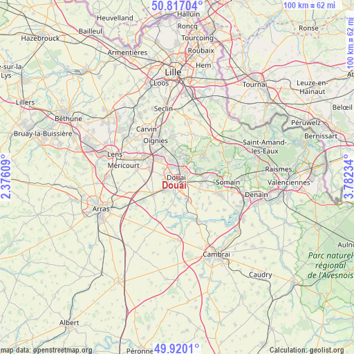
Douai GPS coordinates[2]
50° 22' 14.484" North, 3° 4' 45.192" East
| Map corner | latitude | longitude |
|---|---|---|
| Upper-left | 50.81704°, | 2.37609° |
| Center: | 50.37069°, | 3.07922° |
| Lower-right: | 49.9201°, | 3.78234° |
| Map W x H: | 99.7×99.7 km | = 62×62mi |
| max Lat: | 51.07786° ⇑3.8% North |
| Douai: | 50.37069° |
| min Lat: | ⇓96.2% South 41.3874° |
| min Long | Douai | max Long |
| -5.08615° | 3.07922° | 9.52242° |
| W 59%⇐ | ⇒41% E |
Elevation
Elevation of Douai is 25 m = 82 ft, and this is 168.7 m = 553 ft below average elevation for this country.
| Max E: |
2333 m = 7654 ft | 92% |
| Avg. | 193.7 m = 635 ft | |
| Douai | 25 m = 82 ft | |
Min E: |
-1 m = -3 ft | 8% |
See also: Douai elevation on elevation.city.
Geographical zone
Douai is located in North temperate zone (between Tropic of Cancer and the Arctic Circle). Distance of this North polar circle is 1800.5 km =1118.8 mi to North.| Distance of | km | miles | from Douai |
|---|---|---|---|
| North Pole | 4406.4 | 2738 | to North |
| Arctic Circle | 1800.5 | 1118.8 | to North |
| Tropic Cancer | 2994.8 | 1860.9 | to South |
| Equator | 5600.7 | 3480.1 | to South |


Nearby cities:
15 places around Douai: (largest is in red/bold)
• Auby
5.2 km =3.2 mi,  339°
339°
• Brebières
6.1 km =3.8 mi,  226°
226°
• Corbehem
4.8 km =3 mi,  205°
205°
• Courchelettes
3.6 km =2.2 mi,  202°
202°
• Cuincy
2.1 km =1.3 mi,  297°
297°
• Dechy
3.5 km =2.2 mi,  130°
130°
• Esquerchin
4.7 km =2.9 mi,  276°
276°
• Flers-en-Escrebieux
3.3 km =2.1 mi, 336°
• Férin
4.8 km =3 mi,  184°
184°
• Guesnain
5.5 km =3.4 mi,  114°
114°
• Lambres-lez-Douai
2.5 km =1.6 mi, 201°
• Lauwin-Planque
3.3 km =2.1 mi,  311°
311°
• Roost-Warendin
5.7 km =3.5 mi,  17°
17°
• Sin-le-Noble
3.8 km =2.4 mi, 105°
• Waziers
3.1 km =1.9 mi,  54°
54°
Sources, notices
• [Note1] Compared only with cities in France existing in our database
• [Src1] Map data: © OpenStreetMap contributors (CC-BY-SA)
• [Src2] Other city data from geonames.org with taken over terms of usage.
• [Src3] Geographical zone / Annual Mean Temperature by Robert A. Rohde @ Wikipedia
