Arenthon geodata
Arenthon (Auvergne-Rhône-Alpes) is a populated place; located in France in Europe/Paris (GMT+2) time zone. With population of 1,271 people, there are 7176 cities with bigger population in this country. Compared to other cities in France, 65% of cities are located further ↑North; 90.5% of cities are located further ←West and 90.5% of cities have lower elevation than Arenthon. Note1
Administrative division(s):
- Level 1: Auvergne-Rhône-Alpes
- Level 2: Haute-Savoie
- Level 3: Arrondissement de Bonneville
- Level 4: Arenthon


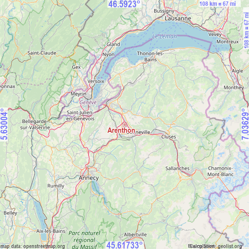
Arenthon GPS coordinates[2]
46° 6' 25.092" North, 6° 19' 59.376" East
| Map corner | latitude | longitude |
|---|---|---|
| Upper-left | 46.5923°, | 5.63004° |
| Center: | 46.10697°, | 6.33316° |
| Lower-right: | 45.61733°, | 7.03629° |
| Map W x H: | 108.4×108.4 km | = 67.4×67.4mi |
| max Lat: | 51.07786° ⇑65% North |
| Arenthon: | 46.10697° |
| min Lat: | ⇓35% South 41.3874° |
| min Long | Arenthon | max Long |
| -5.08615° | 6.33316° | 9.52242° |
| W 90.5%⇐ | ⇒9.5% E |
Elevation
Elevation of Arenthon is 438 m = 1437 ft, and this is 244.3 m = 802 ft above average elevation for this country.
| Max E: |
2333 m = 7654 ft | 9.5% |
| Arenthon | 438 m 1437 ft | |
| Avg. | 193.7 m = 635 ft | |
Min E: |
-1 m = -3 ft | 90.5% |
See also: France elevation on elevation.city.
Geographical zone
Arenthon is located in North temperate zone (between Tropic of Cancer and the Arctic Circle). Distance of this North polar circle is 2274.6 km =1413.4 mi to North.| Distance of | km | miles | from Arenthon |
|---|---|---|---|
| North Pole | 4880.4 | 3032.5 | to North |
| Arctic Circle | 2274.6 | 1413.4 | to North |
| Tropic Cancer | 2520.7 | 1566.3 | to South |
| Equator | 5126.6 | 3185.5 | to South |


Nearby cities:
15 places around Arenthon: (largest is in red/bold)
• Amancy
3.8 km =2.4 mi,  184°
184°
• Bonneville
6.4 km =4 mi,  117°
117°
• Contamine-sur-Arve
3.9 km =2.4 mi,  358°
358°
• Cornier
3.1 km =1.9 mi,  239°
239°
• Etaux
5.2 km =3.2 mi,  214°
214°
• Fillinges
5.9 km =3.7 mi,  6°
6°
• La Roche-sur-Foron
4.6 km =2.9 mi, 208°
• Marcellaz
4.7 km =2.9 mi,  21°
21°
• Nangy
5.7 km =3.5 mi,  338°
338°
• Peillonnex
4.2 km =2.6 mi,  54°
54°
• Pers-Jussy
4.9 km =3 mi,  268°
268°
• Reignier-Ésery
5.9 km =3.7 mi,  299°
299°
• Saint-Jean-de-Tholome
4.8 km =3 mi,  82°
82°
• Saint-Sixt
6.1 km =3.8 mi, 183°
• Scientrier
1.2 km =0.7 mi,  327°
327°
Sources, notices
• [Note1] Compared only with cities in France existing in our database
• [Src1] Map data: © OpenStreetMap contributors (CC-BY-SA)
• [Src2] Other city data from geonames.org with taken over terms of usage.
• [Src3] Geographical zone / Annual Mean Temperature by Robert A. Rohde @ Wikipedia
