Cornier geodata
Cornier (Auvergne-Rhône-Alpes) is a populated place; located in France in Europe/Paris (GMT+2) time zone. With population of 1,039 people, there are 8550 cities with bigger population in this country. Compared to other cities in France, 65.2% of cities are located further ↑North; 90.1% of cities are located further ←West and 92.5% of cities have lower elevation than Cornier. Note1
Administrative division(s):
- Level 1: Auvergne-Rhône-Alpes
- Level 2: Haute-Savoie
- Level 3: Arrondissement de Bonneville
- Level 4: Cornier


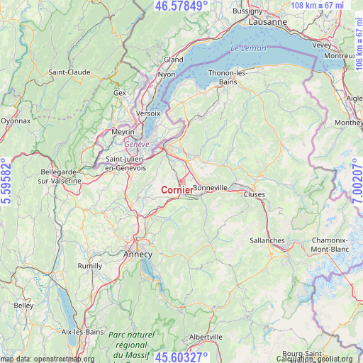
Cornier GPS coordinates[2]
46° 5' 34.944" North, 6° 17' 56.22" East
| Map corner | latitude | longitude |
|---|---|---|
| Upper-left | 46.57849°, | 5.59582° |
| Center: | 46.09304°, | 6.29895° |
| Lower-right: | 45.60327°, | 7.00207° |
| Map W x H: | 108.4×108.4 km | = 67.4×67.4mi |
| max Lat: | 51.07786° ⇑65.2% North |
| Cornier: | 46.09304° |
| min Lat: | ⇓34.8% South 41.3874° |
| min Long | Cornier | max Long |
| -5.08615° | 6.29895° | 9.52242° |
| W 90.1%⇐ | ⇒9.9% E |
Elevation
Elevation of Cornier is 490 m = 1608 ft, and this is 296.3 m = 972 ft above average elevation for this country.
| Max E: |
2333 m = 7654 ft | 7.5% |
| Cornier | 490 m 1608 ft | |
| Avg. | 193.7 m = 635 ft | |
Min E: |
-1 m = -3 ft | 92.5% |
See also: France elevation on elevation.city.
Geographical zone
Cornier is located in North temperate zone (between Tropic of Cancer and the Arctic Circle). Distance of this North polar circle is 2276.1 km =1414.3 mi to North.| Distance of | km | miles | from Cornier |
|---|---|---|---|
| North Pole | 4882 | 3033.5 | to North |
| Arctic Circle | 2276.1 | 1414.3 | to North |
| Tropic Cancer | 2519.1 | 1565.3 | to South |
| Equator | 5125.1 | 3184.6 | to South |


Nearby cities:
15 places around Cornier: (largest is in red/bold)
• Amancy
3.2 km =2 mi,  134°
134°
• Arbusigny
6.2 km =3.9 mi,  270°
270°
• Arenthon
3.1 km =1.9 mi,  59°
59°
• Contamine-sur-Arve
6 km =3.7 mi,  25°
25°
• Etaux
2.8 km =1.7 mi,  185°
185°
• La Roche-sur-Foron
2.5 km =1.6 mi,  170°
170°
• Marcellaz
7.4 km =4.6 mi,  36°
36°
• Nangy
6.9 km =4.3 mi,  4°
4°
• Peillonnex
7.2 km =4.5 mi, 56°
• Pers-Jussy
2.7 km =1.7 mi,  302°
302°
• Reignier-Ésery
5.1 km =3.2 mi,  330°
330°
• Saint-Jean-de-Tholome
7.7 km =4.8 mi,  73°
73°
• Saint-Laurent
7 km =4.3 mi,  138°
138°
• Saint-Sixt
5.1 km =3.2 mi,  153°
153°
• Scientrier
3.2 km =2 mi, 38°
Sources, notices
• [Note1] Compared only with cities in France existing in our database
• [Src1] Map data: © OpenStreetMap contributors (CC-BY-SA)
• [Src2] Other city data from geonames.org with taken over terms of usage.
• [Src3] Geographical zone / Annual Mean Temperature by Robert A. Rohde @ Wikipedia
