Connantre geodata
Connantre (Grand Est) is a populated place; located in France in Europe/Paris (GMT+2) time zone. With population of 1,149 people, there are 7828 cities with bigger population in this country. Compared to other cities in France, 73.8% of cities are located further ↓South; 67.2% of cities are located further ←West and 62% of cities have higher elevation than Connantre. Note1
Administrative division(s):
- Level 1: Grand Est
- Level 2: Marne
- Level 3: Arrondissement d'Épernay
- Level 4: Connantre


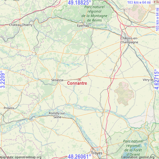
Connantre GPS coordinates[2]
48° 43' 35.652" North, 3° 55' 26.508" East
| Map corner | latitude | longitude |
|---|---|---|
| Upper-left | 49.18825°, | 3.2209° |
| Center: | 48.72657°, | 3.92403° |
| Lower-right: | 48.26061°, | 4.62715° |
| Map W x H: | 103.1×103.1 km | = 64.1×64.1mi |
| max Lat: | 51.07786° ⇑26.2% North |
| Connantre: | 48.72657° |
| min Lat: | ⇓73.8% South 41.3874° |
| min Long | Connantre | max Long |
| -5.08615° | 3.92403° | 9.52242° |
| W 67.2%⇐ | ⇒32.8% E |
Elevation
Elevation of Connantre is 97 m = 318 ft, and this is 96.7 m = 317 ft below average elevation for this country.
| Max E: |
2333 m = 7654 ft | 62% |
| Avg. | 193.7 m = 635 ft | |
| Connantre | 97 m = 318 ft | |
Min E: |
-1 m = -3 ft | 38% |
See also: France elevation on elevation.city.
Geographical zone
Connantre is located in North temperate zone (between Tropic of Cancer and the Arctic Circle). Distance of this North polar circle is 1983.3 km =1232.4 mi to North.| Distance of | km | miles | from Connantre |
|---|---|---|---|
| North Pole | 4589.2 | 2851.6 | to North |
| Arctic Circle | 1983.3 | 1232.4 | to North |
| Tropic Cancer | 2812 | 1747.3 | to South |
| Equator | 5417.9 | 3366.5 | to South |


Nearby cities:
15 places around Connantre: (largest is in red/bold)
• Anglure
17.6 km =10.9 mi,  207°
207°
• Barbonne-Fayel
18.6 km =11.6 mi,  245°
245°
• Bergères-lès-Vertus
18.1 km =11.2 mi,  19°
19°
• Clesles
22.5 km =14 mi,  197°
197°
• Fère-Champenoise
5.8 km =3.6 mi,  57°
57°
• Gaye
10 km =6.2 mi,  241°
241°
• Lucy
25.1 km =15.6 mi,  339°
339°
• Mailly-le-Camp
22.3 km =13.9 mi,  107°
107°
• Marcilly-sur-Seine
24.6 km =15.3 mi,  220°
220°
• Méry-sur-Seine
24.3 km =15.1 mi,  185°
185°
• Plancy-l'Abbaye
18.1 km =11.2 mi,  170°
170°
• Pleurs
5.5 km =3.4 mi, 224°
• Saint-Just-Sauvage
21.7 km =13.5 mi, 208°
• Sézanne
14.7 km =9.1 mi,  267°
267°
• Vertus
20.8 km =12.9 mi, 15°
Sources, notices
• [Note1] Compared only with cities in France existing in our database
• [Src1] Map data: © OpenStreetMap contributors (CC-BY-SA)
• [Src2] Other city data from geonames.org with taken over terms of usage.
• [Src3] Geographical zone / Annual Mean Temperature by Robert A. Rohde @ Wikipedia
