Comines geodata
Comines (Hauts-de-France) is a populated place; located in France in Europe/Paris (GMT+2) time zone. With population of 12,548 people, there are 759 cities with bigger population in this country. Compared to other cities in France, 99.1% of cities are located further ↓South; 58% of cities are located further ←West and 94.7% of cities have higher elevation than Comines. Note1
Administrative division(s):
- Level 1: Hauts-de-France
- Level 2: Nord
- Level 3: Arrondissement de Lille
- Level 4: Comines


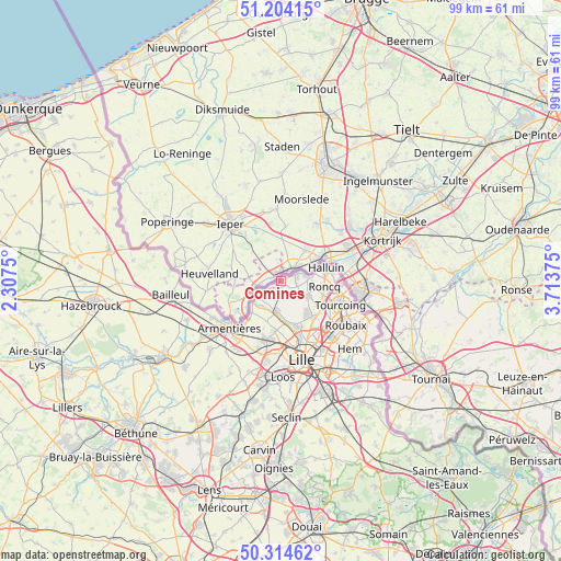
Comines GPS coordinates[2]
50° 45' 41.4" North, 3° 0' 38.268" East
| Map corner | latitude | longitude |
|---|---|---|
| Upper-left | 51.20415°, | 2.3075° |
| Center: | 50.7615°, | 3.01063° |
| Lower-right: | 50.31462°, | 3.71375° |
| Map W x H: | 98.9×98.9 km | = 61.5×61.5mi |
| max Lat: | 51.07786° ⇑0.9% North |
| Comines: | 50.7615° |
| min Lat: | ⇓99.1% South 41.3874° |
| min Long | Comines | max Long |
| -5.08615° | 3.01063° | 9.52242° |
| W 58%⇐ | ⇒42% E |
Elevation
Elevation of Comines is 18 m = 59 ft, and this is 175.7 m = 576 ft below average elevation for this country.
| Max E: |
2333 m = 7654 ft | 94.7% |
| Avg. | 193.7 m = 635 ft | |
| Comines | 18 m = 59 ft | |
Min E: |
-1 m = -3 ft | 5.3% |
See also: France elevation on elevation.city.
Geographical zone
Comines is located in North temperate zone (between Tropic of Cancer and the Arctic Circle). Distance of this North polar circle is 1757 km =1091.7 mi to North.| Distance of | km | miles | from Comines |
|---|---|---|---|
| North Pole | 4362.9 | 2711 | to North |
| Arctic Circle | 1757 | 1091.7 | to North |
| Tropic Cancer | 3038.2 | 1887.8 | to South |
| Equator | 5644.1 | 3507.1 | to South |


Nearby cities:
15 places around Comines: (largest is in red/bold)
• Bondues
8.9 km =5.5 mi,  138°
138°
• Bousbecque
5.3 km =3.3 mi,  78°
78°
• Deûlémont
5.3 km =3.3 mi,  233°
233°
• Frelinghien
7.4 km =4.6 mi, 227°
• Halluin
8.6 km =5.3 mi,  71°
71°
• Houplines
10 km =6.2 mi,  222°
222°
• Linselles
5.5 km =3.4 mi,  119°
119°
• Lompret
10.4 km =6.5 mi,  188°
188°
• Marquette-lez-Lille
10.2 km =6.3 mi,  157°
157°
• Neuville-en-Ferrain
10.4 km =6.5 mi,  98°
98°
• Quesnoy-sur-Deûle
5.4 km =3.4 mi, 188°
• Roncq
7.8 km =4.8 mi, 96°
• Verlinghem
8.8 km =5.5 mi, 185°
• Wambrechies
9.1 km =5.7 mi, 163°
• Wervicq-Sud
2.6 km =1.6 mi,  56°
56°
Sources, notices
• [Note1] Compared only with cities in France existing in our database
• [Src1] Map data: © OpenStreetMap contributors (CC-BY-SA)
• [Src2] Other city data from geonames.org with taken over terms of usage.
• [Src3] Geographical zone / Annual Mean Temperature by Robert A. Rohde @ Wikipedia
