Deûlémont geodata
Deûlémont (Hauts-de-France) is a populated place; located in France in Europe/Paris (GMT+2) time zone. With population of 1,494 people, there are 6209 cities with bigger population in this country. Compared to other cities in France, 99% of cities are located further ↓South; 57.1% of cities are located further ←West and 95% of cities have higher elevation than Deûlémont. Note1
Administrative division(s):
- Level 1: Hauts-de-France
- Level 2: Nord
- Level 3: Arrondissement de Lille
- Level 4: Deûlémont


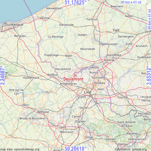
Deûlémont GPS coordinates[2]
50° 43' 59.988" North, 2° 57' 0" East
| Map corner | latitude | longitude |
|---|---|---|
| Upper-left | 51.17625°, | 2.24687° |
| Center: | 50.73333°, | 2.95° |
| Lower-right: | 50.28618°, | 3.65312° |
| Map W x H: | 99×99 km | = 61.5×61.5mi |
| max Lat: | 51.07786° ⇑1% North |
| Deûlémont: | 50.73333° |
| min Lat: | ⇓99% South 41.3874° |
| min Long | Deûlémont | max Long |
| -5.08615° | 2.95° | 9.52242° |
| W 57.1%⇐ | ⇒42.9% E |
Elevation
Elevation of Deûlémont is 17 m = 56 ft, and this is 176.7 m = 580 ft below average elevation for this country.
| Max E: |
2333 m = 7654 ft | 95% |
| Avg. | 193.7 m = 635 ft | |
| Deûlémont | 17 m = 56 ft | |
Min E: |
-1 m = -3 ft | 5% |
See also: France elevation on elevation.city.
Geographical zone
Deûlémont is located in North temperate zone (between Tropic of Cancer and the Arctic Circle). Distance of this North polar circle is 1760.2 km =1093.7 mi to North.| Distance of | km | miles | from Deûlémont |
|---|---|---|---|
| North Pole | 4366 | 2712.9 | to North |
| Arctic Circle | 1760.2 | 1093.7 | to North |
| Tropic Cancer | 3035.1 | 1885.9 | to South |
| Equator | 5641 | 3505.2 | to South |


Nearby cities:
15 places around Deûlémont: (largest is in red/bold)
• Armentières
7.1 km =4.4 mi,  222°
222°
• Capinghem
9.8 km =6.1 mi,  175°
175°
• Comines
5.3 km =3.3 mi,  53°
53°
• Erquinghem-Lys
9.8 km =6.1 mi,  229°
229°
• Frelinghien
2.2 km =1.4 mi,  212°
212°
• Houplines
4.9 km =3 mi, 209°
• Linselles
9.1 km =5.7 mi,  87°
87°
• Lompret
7.6 km =4.7 mi,  158°
158°
• Nieppe
8.7 km =5.4 mi,  248°
248°
• Prémesques
8.6 km =5.3 mi, 179°
• Pérenchies
7.2 km =4.5 mi,  168°
168°
• Quesnoy-sur-Deûle
4.1 km =2.5 mi,  121°
121°
• Verlinghem
6.6 km =4.1 mi,  148°
148°
• Wambrechies
8.9 km =5.5 mi,  129°
129°
• Wervicq-Sud
7.9 km =4.9 mi, 54°
Sources, notices
• [Note1] Compared only with cities in France existing in our database
• [Src1] Map data: © OpenStreetMap contributors (CC-BY-SA)
• [Src2] Other city data from geonames.org with taken over terms of usage.
• [Src3] Geographical zone / Annual Mean Temperature by Robert A. Rohde @ Wikipedia
