Colombes geodata
Colombes (Île-de-France) is a populated place; located in France in Europe/Paris (GMT+2) time zone. With population of 82,300 people, there are 52 cities with bigger population in this country. Compared to other cities in France, 77.9% of cities are located further ↓South; 53.4% of cities are located further →East and 85.9% of cities have higher elevation than Colombes. Note1
Administrative division(s):
- Level 1: Île-de-France
- Level 2: Hauts-de-Seine
- Level 3: Arrondissement de Nanterre
- Level 4: Colombes


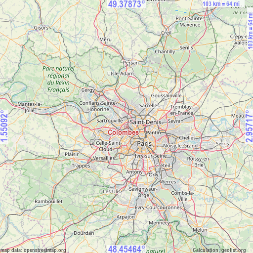
Colombes GPS coordinates[2]
48° 55' 7.752" North, 2° 15' 14.544" East
| Map corner | latitude | longitude |
|---|---|---|
| Upper-left | 49.37873°, | 1.55092° |
| Center: | 48.91882°, | 2.25404° |
| Lower-right: | 48.45464°, | 2.95717° |
| Map W x H: | 102.7×102.7 km | = 63.8×63.8mi |
| max Lat: | 51.07786° ⇑22.1% North |
| Colombes: | 48.91882° |
| min Lat: | ⇓77.9% South 41.3874° |
| min Long | Colombes | max Long |
| -5.08615° | 2.25404° | 9.52242° |
| W 46.6%⇐ | ⇒53.4% E |
Elevation
Elevation of Colombes is 40 m = 131 ft, and this is 153.7 m = 504 ft below average elevation for this country.
| Max E: |
2333 m = 7654 ft | 85.9% |
| Avg. | 193.7 m = 635 ft | |
| Colombes | 40 m = 131 ft | |
Min E: |
-1 m = -3 ft | 14.1% |
See also: Colombes elevation on elevation.city.
Geographical zone
Colombes is located in North temperate zone (between Tropic of Cancer and the Arctic Circle). Distance of this North polar circle is 1961.9 km =1219.1 mi to North.| Distance of | km | miles | from Colombes |
|---|---|---|---|
| North Pole | 4567.8 | 2838.3 | to North |
| Arctic Circle | 1961.9 | 1219.1 | to North |
| Tropic Cancer | 2833.3 | 1760.5 | to South |
| Equator | 5439.3 | 3379.8 | to South |


Nearby cities:
15 places around Colombes: (largest is in red/bold)
• Argenteuil
3.3 km =2.1 mi,  351°
351°
• Asnières-sur-Seine
2.2 km =1.4 mi,  96°
96°
• Bezons
3.1 km =1.9 mi,  281°
281°
• Bois-Colombes
1.5 km =0.9 mi,  87°
87°
• Clichy
4.6 km =2.9 mi,  117°
117°
• Courbevoie
2.5 km =1.6 mi,  175°
175°
• Gennevilliers
3.7 km =2.3 mi,  64°
64°
• Houilles
4.5 km =2.8 mi,  273°
273°
• La Defense
3.2 km =2 mi,  200°
200°
• La Garenne-Colombes
1.7 km =1.1 mi, 198°
• Levallois-Perret
3.8 km =2.4 mi,  137°
137°
• Nanterre
4.6 km =2.9 mi,  229°
229°
• Neuilly-sur-Seine
4 km =2.5 mi,  163°
163°
• Puteaux
4.1 km =2.5 mi, 195°
• Villeneuve-la-Garenne
5 km =3.1 mi, 62°
Sources, notices
• [Note1] Compared only with cities in France existing in our database
• [Src1] Map data: © OpenStreetMap contributors (CC-BY-SA)
• [Src2] Other city data from geonames.org with taken over terms of usage.
• [Src3] Geographical zone / Annual Mean Temperature by Robert A. Rohde @ Wikipedia
