Neuilly-sur-Seine geodata
Neuilly-sur-Seine (Île-de-France) is a populated place; located in France in Europe/Paris (GMT+2) time zone. With population of 61,300 people, there are 82 cities with bigger population in this country. Compared to other cities in France, 77.3% of cities are located further ↓South; 53.2% of cities are located further →East and 85.9% of cities have higher elevation than Neuilly-sur-Seine. Note1
Administrative division(s):
- Level 1: Île-de-France
- Level 2: Hauts-de-Seine
- Level 3: Arrondissement de Nanterre
- Level 4: Neuilly-sur-Seine


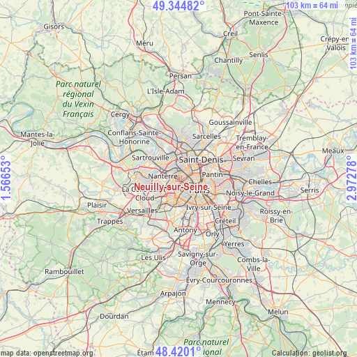
Neuilly-sur-Seine GPS coordinates[2]
48° 53' 4.56" North, 2° 16' 10.74" East
| Map corner | latitude | longitude |
|---|---|---|
| Upper-left | 49.34482°, | 1.56653° |
| Center: | 48.8846°, | 2.26965° |
| Lower-right: | 48.4201°, | 2.97278° |
| Map W x H: | 102.8×102.8 km | = 63.9×63.9mi |
| max Lat: | 51.07786° ⇑22.7% North |
| Neuilly-sur-Seine: | 48.8846° |
| min Lat: | ⇓77.3% South 41.3874° |
| min Long | Neuilly-sur-Sei | max Long |
| -5.08615° | 2.26965° | 9.52242° |
| W 46.8%⇐ | ⇒53.2% E |
Elevation
Elevation of Neuilly-sur-Seine is 40 m = 131 ft, and this is 153.7 m = 504 ft below average elevation for this country.
| Max E: |
2333 m = 7654 ft | 85.9% |
| Avg. | 193.7 m = 635 ft | |
| Neuilly-sur-Seine | 40 m = 131 ft | |
Min E: |
-1 m = -3 ft | 14.1% |
See also: Neuilly-sur-Seine elevation on elevation.city.
Geographical zone
Neuilly-sur-Seine is located in North temperate zone (between Tropic of Cancer and the Arctic Circle). Distance of this North polar circle is 1965.7 km =1221.4 mi to North.| Distance of | km | miles | from Neuilly-sur-Seine |
|---|---|---|---|
| North Pole | 4571.6 | 2840.7 | to North |
| Arctic Circle | 1965.7 | 1221.4 | to North |
| Tropic Cancer | 2829.5 | 1758.2 | to South |
| Equator | 5435.5 | 3377.5 | to South |


Nearby cities:
15 places around Neuilly-sur-Seine: (largest is in red/bold)
• Asnières-sur-Seine
3.7 km =2.3 mi,  15°
15°
• Bois-Colombes
3.9 km =2.4 mi,  5°
5°
• Boulogne-Billancourt
5.8 km =3.6 mi,  200°
200°
• Clichy
3.4 km =2.1 mi,  59°
59°
• Colombes
4 km =2.5 mi,  343°
343°
• Courbevoie
1.6 km =1 mi,  324°
324°
• Gennevilliers
5.9 km =3.7 mi, 22°
• La Defense
2.4 km =1.5 mi,  289°
289°
• La Garenne-Colombes
2.8 km =1.7 mi, 323°
• Levallois-Perret
1.7 km =1.1 mi,  53°
53°
• Nanterre
4.7 km =2.9 mi,  280°
280°
• Puteaux
2.2 km =1.4 mi,  266°
266°
• Rueil-Malmaison
5.9 km =3.7 mi,  261°
261°
• Saint-Ouen
5.3 km =3.3 mi, 62°
• Suresnes
3.3 km =2.1 mi,  243°
243°
Sources, notices
• [Note1] Compared only with cities in France existing in our database
• [Src1] Map data: © OpenStreetMap contributors (CC-BY-SA)
• [Src2] Other city data from geonames.org with taken over terms of usage.
• [Src3] Geographical zone / Annual Mean Temperature by Robert A. Rohde @ Wikipedia
