Clichy geodata
Clichy (Île-de-France) is a populated place; located in France in Europe/Paris (GMT+2) time zone. With population of 57,467 people, there are 94 cities with bigger population in this country. Compared to other cities in France, 77.6% of cities are located further ↓South; 52.5% of cities are located further →East and 87.8% of cities have higher elevation than Clichy. Note1
Administrative division(s):
- Level 1: Île-de-France
- Level 2: Hauts-de-Seine
- Level 3: Arrondissement de Nanterre
- Level 4: Clichy


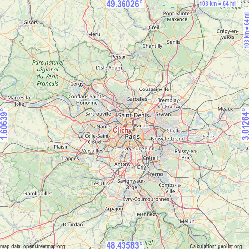
Clichy GPS coordinates[2]
48° 54' 0.648" North, 2° 18' 34.272" East
| Map corner | latitude | longitude |
|---|---|---|
| Upper-left | 49.36026°, | 1.60639° |
| Center: | 48.90018°, | 2.30952° |
| Lower-right: | 48.43583°, | 3.01264° |
| Map W x H: | 102.8×102.8 km | = 63.9×63.9mi |
| max Lat: | 51.07786° ⇑22.4% North |
| Clichy: | 48.90018° |
| min Lat: | ⇓77.6% South 41.3874° |
| min Long | Clichy | max Long |
| -5.08615° | 2.30952° | 9.52242° |
| W 47.5%⇐ | ⇒52.5% E |
Elevation
Elevation of Clichy is 35 m = 115 ft, and this is 158.7 m = 521 ft below average elevation for this country.
| Max E: |
2333 m = 7654 ft | 87.8% |
| Avg. | 193.7 m = 635 ft | |
| Clichy | 35 m = 115 ft | |
Min E: |
-1 m = -3 ft | 12.2% |
See also: Clichy elevation on elevation.city.
Geographical zone
Clichy is located in North temperate zone (between Tropic of Cancer and the Arctic Circle). Distance of this North polar circle is 1964 km =1220.4 mi to North.| Distance of | km | miles | from Clichy |
|---|---|---|---|
| North Pole | 4569.9 | 2839.6 | to North |
| Arctic Circle | 1964 | 1220.4 | to North |
| Tropic Cancer | 2831.3 | 1759.3 | to South |
| Equator | 5437.2 | 3378.5 | to South |


Nearby cities:
15 places around Clichy: (largest is in red/bold)
• Asnières-sur-Seine
2.7 km =1.7 mi,  313°
313°
• Aubervilliers
5.7 km =3.5 mi,  71°
71°
• Bois-Colombes
3.3 km =2.1 mi, 310°
• Colombes
4.6 km =2.9 mi,  297°
297°
• Courbevoie
3.9 km =2.4 mi,  264°
264°
• Gennevilliers
3.8 km =2.4 mi,  349°
349°
• La Defense
5.2 km =3.2 mi, 259°
• La Garenne-Colombes
4.6 km =2.9 mi,  276°
276°
• Levallois-Perret
1.7 km =1.1 mi,  245°
245°
• Neuilly-sur-Seine
3.4 km =2.1 mi,  239°
239°
• Puteaux
5.5 km =3.4 mi, 250°
• Saint-Denis
5.1 km =3.2 mi,  39°
39°
• Saint-Ouen
1.9 km =1.2 mi, 67°
• Villeneuve-la-Garenne
4.4 km =2.7 mi,  5°
5°
• Épinay-sur-Seine
5.9 km =3.7 mi,  3°
3°
Sources, notices
• [Note1] Compared only with cities in France existing in our database
• [Src1] Map data: © OpenStreetMap contributors (CC-BY-SA)
• [Src2] Other city data from geonames.org with taken over terms of usage.
• [Src3] Geographical zone / Annual Mean Temperature by Robert A. Rohde @ Wikipedia
