Nanterre geodata
Nanterre (Île-de-France) is a seat of a second-order administrative division; located in France in Europe/Paris (GMT+2) time zone. With population of 86,719 people, there are 46 cities with bigger population in this country. Compared to other cities in France, 77.4% of cities are located further ↓South; 54.3% of cities are located further →East and 81.8% of cities have higher elevation than Nanterre. Note1
Administrative division(s):
- Level 1: Île-de-France
- Level 2: Hauts-de-Seine
- Level 3: Arrondissement de Nanterre
- Level 4: Nanterre


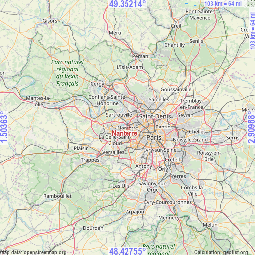
Nanterre GPS coordinates[2]
48° 53' 31.128" North, 2° 12' 24.3" East
| Map corner | latitude | longitude |
|---|---|---|
| Upper-left | 49.35214°, | 1.50363° |
| Center: | 48.89198°, | 2.20675° |
| Lower-right: | 48.42755°, | 2.90988° |
| Map W x H: | 102.8×102.8 km | = 63.9×63.9mi |
| max Lat: | 51.07786° ⇑22.6% North |
| Nanterre: | 48.89198° |
| min Lat: | ⇓77.4% South 41.3874° |
| min Long | Nanterre | max Long |
| -5.08615° | 2.20675° | 9.52242° |
| W 45.7%⇐ | ⇒54.3% E |
Elevation
Elevation of Nanterre is 50 m = 164 ft, and this is 143.7 m = 471 ft below average elevation for this country.
| Max E: |
2333 m = 7654 ft | 81.8% |
| Avg. | 193.7 m = 635 ft | |
| Nanterre | 50 m = 164 ft | |
Min E: |
-1 m = -3 ft | 18.2% |
See also: Nanterre elevation on elevation.city.
Geographical zone
Nanterre is located in North temperate zone (between Tropic of Cancer and the Arctic Circle). Distance of this North polar circle is 1964.9 km =1220.9 mi to North.| Distance of | km | miles | from Nanterre |
|---|---|---|---|
| North Pole | 4570.8 | 2840.2 | to North |
| Arctic Circle | 1964.9 | 1220.9 | to North |
| Tropic Cancer | 2830.4 | 1758.7 | to South |
| Equator | 5436.3 | 3378 | to South |


Nearby cities:
15 places around Nanterre: (largest is in red/bold)
• Bezons
3.6 km =2.2 mi,  7°
7°
• Carrières-sur-Seine
2.6 km =1.6 mi,  309°
309°
• Chatou
3.5 km =2.2 mi,  266°
266°
• Colombes
4.6 km =2.9 mi,  49°
49°
• Courbevoie
3.7 km =2.3 mi,  81°
81°
• Croissy-sur-Seine
5.2 km =3.2 mi,  254°
254°
• Houilles
3.5 km =2.2 mi,  342°
342°
• La Defense
2.3 km =1.4 mi,  90°
90°
• La Garenne-Colombes
3.3 km =2.1 mi,  64°
64°
• Le Vésinet
5.4 km =3.4 mi, 270°
• Neuilly-sur-Seine
4.7 km =2.9 mi,  100°
100°
• Puteaux
2.5 km =1.6 mi,  112°
112°
• Rueil-Malmaison
2.1 km =1.3 mi,  215°
215°
• Saint-Cloud
5.1 km =3.2 mi,  183°
183°
• Suresnes
2.8 km =1.7 mi,  144°
144°
Sources, notices
• [Note1] Compared only with cities in France existing in our database
• [Src1] Map data: © OpenStreetMap contributors (CC-BY-SA)
• [Src2] Other city data from geonames.org with taken over terms of usage.
• [Src3] Geographical zone / Annual Mean Temperature by Robert A. Rohde @ Wikipedia
