Saint-Martin-du-Var geodata
Saint-Martin-du-Var (Provence-Alpes-Côte d'Azur) is a populated place; located in France in Europe/Paris (GMT+2) time zone. With population of 2,283 people, there are 4223 cities with bigger population in this country. Compared to other cities in France, 88.9% of cities are located further ↑North; 95.8% of cities are located further ←West and 59.1% of cities have higher elevation than Saint-Martin-du-Var. Note1
Administrative division(s):
- Level 1: Provence-Alpes-Côte d'Azur
- Level 2: Alpes-Maritimes
- Level 3: Arrondissement de Nice
- Level 4: Saint-Martin-du-Var


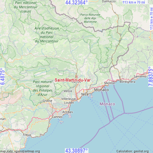
Saint-Martin-du-Var GPS coordinates[2]
43° 49' 6.456" North, 7° 11' 26.232" East
| Map corner | latitude | longitude |
|---|---|---|
| Upper-left | 44.32364°, | 6.4875° |
| Center: | 43.81846°, | 7.19062° |
| Lower-right: | 43.30897°, | 7.89375° |
| Map W x H: | 112.8×112.8 km | = 70.1×70.1mi |
| max Lat: | 51.07786° ⇑88.9% North |
| Saint-Martin-du-Var: | 43.81846° |
| min Lat: | ⇓11.1% South 41.3874° |
| min Long | Saint-Martin-du | max Long |
| -5.08615° | 7.19062° | 9.52242° |
| W 95.8%⇐ | ⇒4.2% E |
Elevation
Elevation of Saint-Martin-du-Var is 105 m = 344 ft, and this is 88.7 m = 291 ft below average elevation for this country.
| Max E: |
2333 m = 7654 ft | 59.1% |
| Avg. | 193.7 m = 635 ft | |
| Saint-Martin-du-Var | 105 m = 344 ft | |
Min E: |
-1 m = -3 ft | 40.9% |
See also: France elevation on elevation.city.
Geographical zone
Saint-Martin-du-Var is located in North temperate zone (between Tropic of Cancer and the Arctic Circle). Distance of this Northern Tropic circle is 2266.2 km =1408.2 mi to South.| Distance of | km | miles | from Saint-Martin-du-Var |
|---|---|---|---|
| North Pole | 5134.9 | 3190.7 | to North |
| Arctic Circle | 2529 | 1571.4 | to North |
| Tropic Cancer | 2266.2 | 1408.2 | to South |
| Equator | 4872.2 | 3027.4 | to South |


Nearby cities:
15 places around Saint-Martin-du-Var: (largest is in red/bold)
• Aspremont
5.8 km =3.6 mi,  132°
132°
• Bendejun
8.5 km =5.3 mi,  76°
76°
• Bonson
4.9 km =3 mi,  359°
359°
• Carros
2.9 km =1.8 mi,  185°
185°
• Castagniers
4.5 km =2.8 mi, 132°
• Coaraze
9.8 km =6.1 mi,  58°
58°
• Colomars
6.6 km =4.1 mi,  157°
157°
• Gattières
6.7 km =4.2 mi, 190°
• Gilette
4.1 km =2.5 mi,  327°
327°
• La Roquette-sur-Var
1.3 km =0.8 mi,  32°
32°
• Le Broc
2.1 km =1.3 mi,  238°
238°
• Levens
5.4 km =3.4 mi, 31°
• Saint-Blaise
3.8 km =2.4 mi, 84°
• Saint-Jeannet
8.8 km =5.5 mi,  205°
205°
• Tourrette-Levens
7.7 km =4.8 mi,  117°
117°
Sources, notices
• [Note1] Compared only with cities in France existing in our database
• [Src1] Map data: © OpenStreetMap contributors (CC-BY-SA)
• [Src2] Other city data from geonames.org with taken over terms of usage.
• [Src3] Geographical zone / Annual Mean Temperature by Robert A. Rohde @ Wikipedia
