Castagniers geodata
Castagniers (Provence-Alpes-Côte d'Azur) is a populated place; located in France in Europe/Paris (GMT+2) time zone. With population of 1,407 people, there are 6578 cities with bigger population in this country. Compared to other cities in France, 89.2% of cities are located further ↑North; 96% of cities are located further ←West and 86.3% of cities have lower elevation than Castagniers. Note1
Administrative division(s):
- Level 1: Provence-Alpes-Côte d'Azur
- Level 2: Alpes-Maritimes
- Level 3: Arrondissement de Nice
- Level 4: Castagniers


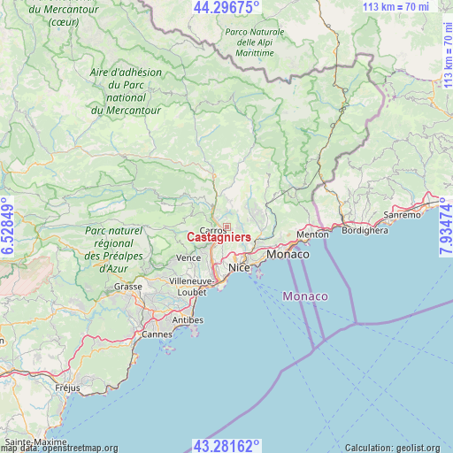
Castagniers GPS coordinates[2]
43° 47' 28.824" North, 7° 13' 53.832" East
| Map corner | latitude | longitude |
|---|---|---|
| Upper-left | 44.29675°, | 6.52849° |
| Center: | 43.79134°, | 7.23162° |
| Lower-right: | 43.28162°, | 7.93474° |
| Map W x H: | 112.9×112.9 km | = 70.2×70.2mi |
| max Lat: | 51.07786° ⇑89.2% North |
| Castagniers: | 43.79134° |
| min Lat: | ⇓10.8% South 41.3874° |
| min Long | Castagniers | max Long |
| -5.08615° | 7.23162° | 9.52242° |
| W 96%⇐ | ⇒4% E |
Elevation
Elevation of Castagniers is 364 m = 1194 ft, and this is 170.3 m = 559 ft above average elevation for this country.
| Max E: |
2333 m = 7654 ft | 13.7% |
| Castagniers | 364 m 1194 ft | |
| Avg. | 193.7 m = 635 ft | |
Min E: |
-1 m = -3 ft | 86.3% |
See also: France elevation on elevation.city.
Geographical zone
Castagniers is located in North temperate zone (between Tropic of Cancer and the Arctic Circle). Distance of this Northern Tropic circle is 2263.2 km =1406.3 mi to South.| Distance of | km | miles | from Castagniers |
|---|---|---|---|
| North Pole | 5137.9 | 3192.5 | to North |
| Arctic Circle | 2532 | 1573.3 | to North |
| Tropic Cancer | 2263.2 | 1406.3 | to South |
| Equator | 4869.1 | 3025.5 | to South |


Nearby cities:
15 places around Castagniers: (largest is in red/bold)
• Aspremont
1.3 km =0.8 mi,  131°
131°
• Bendejun
7.1 km =4.4 mi,  45°
45°
• Cantaron
7.6 km =4.7 mi,  115°
115°
• Carros
3.5 km =2.2 mi,  272°
272°
• Colomars
3.2 km =2 mi,  193°
193°
• Contes
7.1 km =4.4 mi,  70°
70°
• Falicon
6.1 km =3.8 mi,  141°
141°
• Gattières
5.7 km =3.5 mi,  231°
231°
• La Roquette-sur-Var
4.9 km =3 mi,  327°
327°
• Le Broc
5.4 km =3.4 mi,  291°
291°
• Levens
7.6 km =4.7 mi,  356°
356°
• Saint-André-de-la-Roche
7.7 km =4.8 mi,  147°
147°
• Saint-Blaise
3.4 km =2.1 mi,  8°
8°
• Saint-Martin-du-Var
4.5 km =2.8 mi,  312°
312°
• Tourrette-Levens
3.6 km =2.2 mi,  98°
98°
Sources, notices
• [Note1] Compared only with cities in France existing in our database
• [Src1] Map data: © OpenStreetMap contributors (CC-BY-SA)
• [Src2] Other city data from geonames.org with taken over terms of usage.
• [Src3] Geographical zone / Annual Mean Temperature by Robert A. Rohde @ Wikipedia
